




The GATE 2026 Geomatics Engineering (GE) question paper is now available with detailed solutions for free download. GATE 2026 was conducted by IIT Guwahati in February 2026, and the GE paper carried 65 questions for 100 marks in a 3-hour computer-based test.
| GATE 2026 Geomatics Engineering Question Paper with Solutions | Download PDF | Check Solutions |
GATE 2026 Geomatics Engineering Questions with Solutions
"He often _____ the numbers. False claims are not going to help. Honesty _____ trust", said the manager.
Choose the option with the correct order of words to fill the blanks.
In the sequence of tiles shown below, the missing tile indicated by the question mark should be

- (A)
![]()
- (B)
![]()
- (C)
![]()
- (D)
![]()


A school has 100 students distributed among 1st to 10th standards.
Based on this, which one of the following statements is always correct?
How many 3-digit numbers can be formed using three distinct single digit prime numbers?
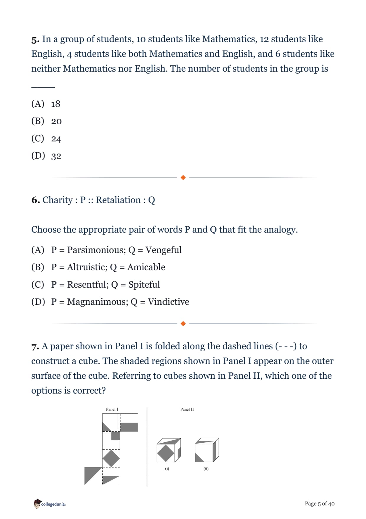
In a group of students, 10 students like Mathematics, 12 students like English, 4 students like both Mathematics and English, and 6 students like neither Mathematics nor English. The number of students in the group is ____
Charity : P :: Retaliation : Q
Choose the appropriate pair of words P and Q that fit the analogy.
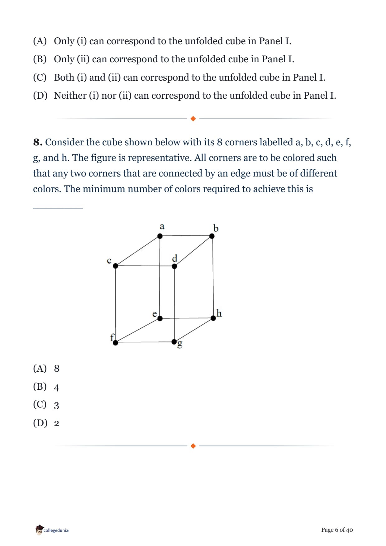
A paper shown in Panel I is folded along the dashed lines (- - -) to construct a cube. The shaded regions shown in Panel I appear on the outer surface of the cube. Referring to cubes shown in Panel II, which one of the options is correct?

Consider the cube shown below with its 8 corners labelled a, b, c, d, e, f, g, and h. The figure is representative. All corners are to be colored such that any two corners that are connected by an edge must be of different colors. The minimum number of colors required to achieve this is ________

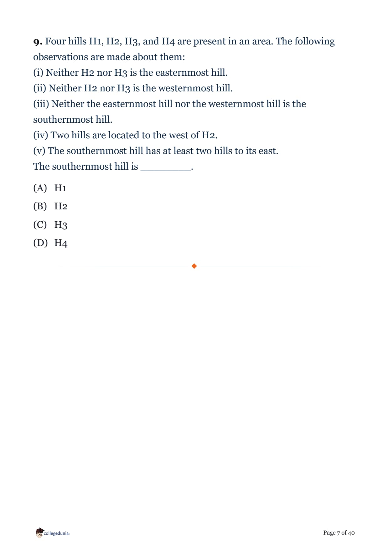
Four hills H1, H2, H3, and H4 are present in an area. The following observations are made about them:
(i) Neither H2 nor H3 is the easternmost hill.
(ii) Neither H2 nor H3 is the westernmost hill.
(iii) Neither the easternmost hill nor the westernmost hill is the southernmost hill.
(iv) Two hills are located to the west of H2.
(v) The southernmost hill has at least two hills to its east.
The southernmost hill is ________.
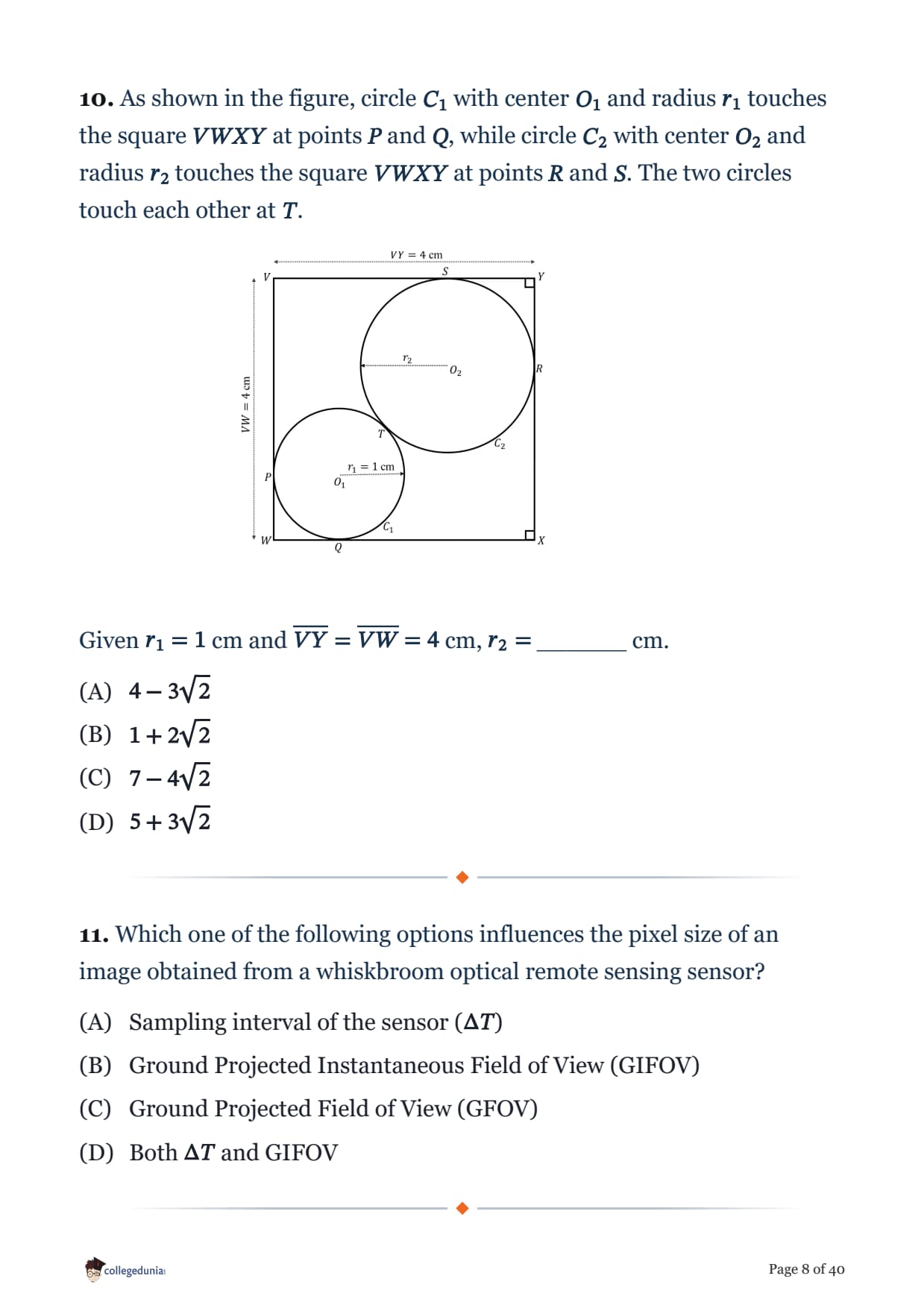
As shown in the figure, circle \(C_1\) with center \(O_1\) and radius \(r_1\) touches the square \(VWXY\) at points \(P\) and \(Q\), while circle \(C_2\) with center \(O_2\) and radius \(r_2\) touches the square \(VWXY\) at points \(R\) and \(S\). The two circles touch each other at \(T\).

Given \(r_1 = 1\) cm and \(\overline{VY} = \overline{VW} = 4\) cm, \(r_2 =\) ______ cm.
Which one of the following options influences the pixel size of an image obtained from a whiskbroom optical remote sensing sensor?
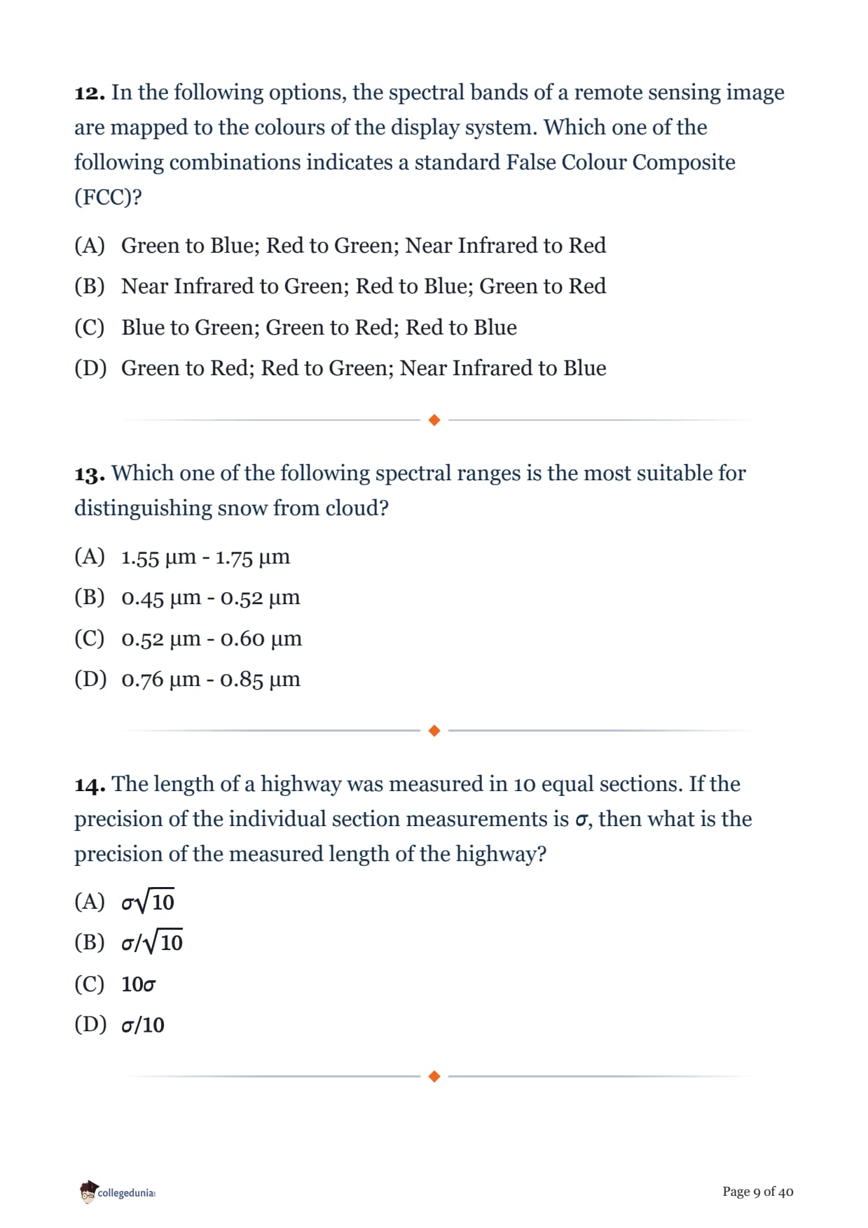
In the following options, the spectral bands of a remote sensing image are mapped to the colours of the display system. Which one of the following combinations indicates a standard False Colour Composite (FCC)?
Which one of the following spectral ranges is the most suitable for distinguishing snow from cloud?
The length of a highway was measured in 10 equal sections. If the precision of the individual section measurements is \(\sigma\), then what is the precision of the measured length of the highway?
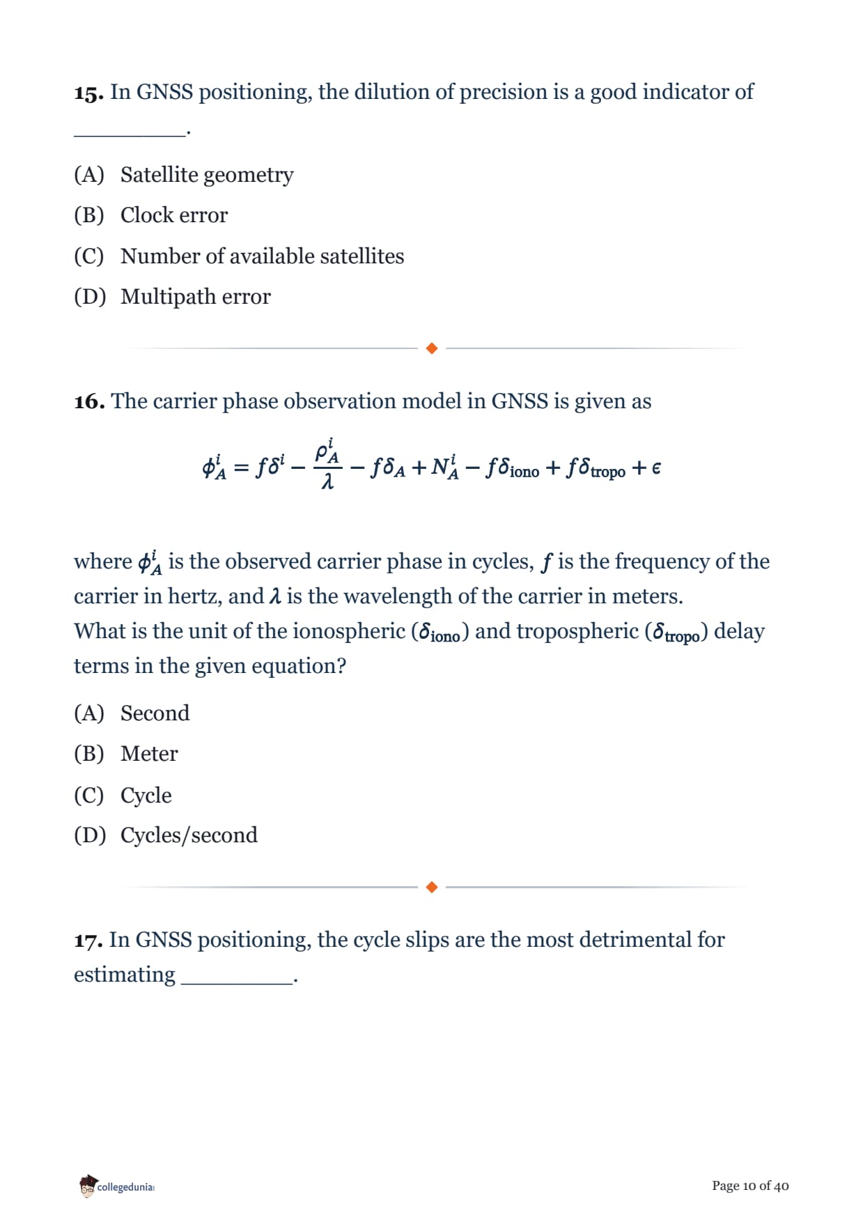
In GNSS positioning, the dilution of precision is a good indicator of ________.
The carrier phase observation model in GNSS is given as
\[ \phi_A^i = f\delta^i - \frac{\rho_A^i}{\lambda} - f\delta_A + N_A^i - f\delta_{\text{iono}} + f\delta_{\text{tropo}} + \epsilon \]
where \(\phi_A^i\) is the observed carrier phase in cycles, \(f\) is the frequency of the carrier in hertz, and \(\lambda\) is the wavelength of the carrier in meters.
What is the unit of the ionospheric (\(\delta_{\text{iono}}\)) and tropospheric (\(\delta_{\text{tropo}}\)) delay terms in the given equation?
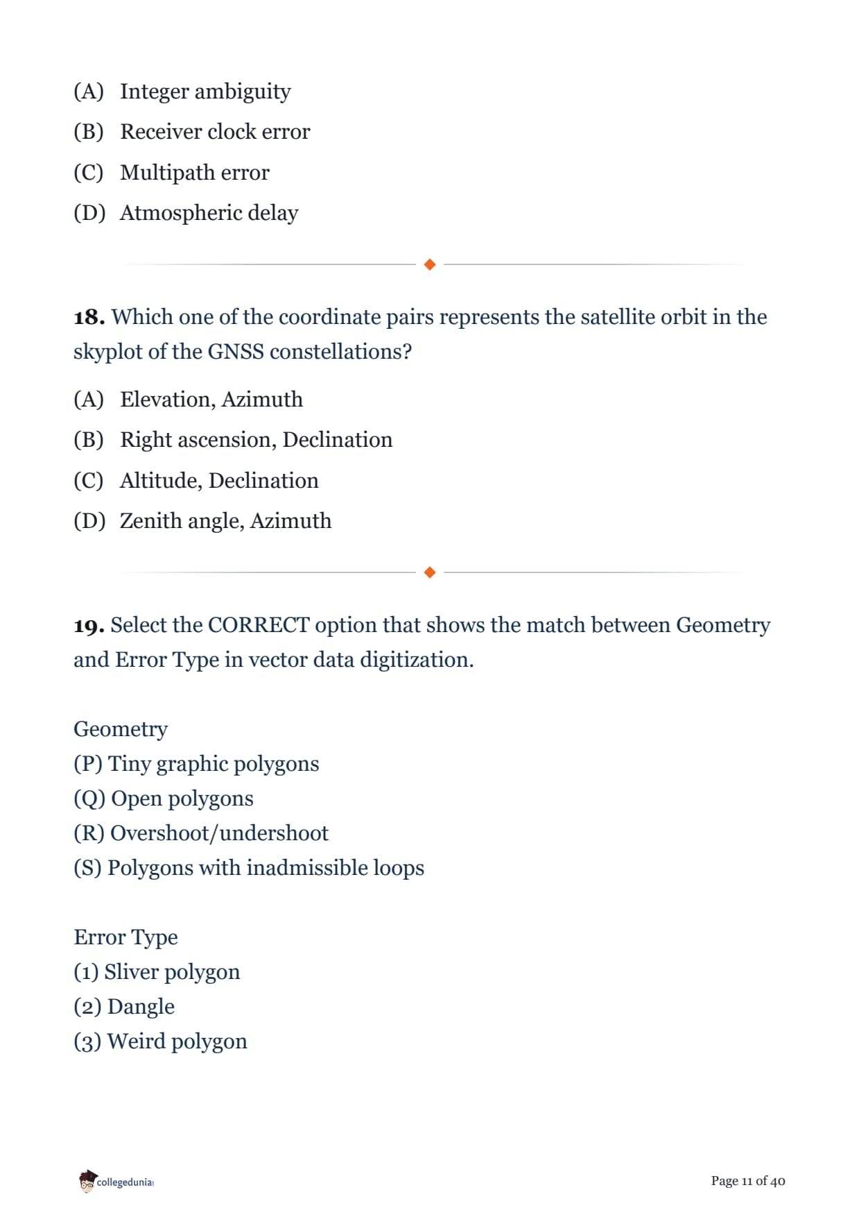
In GNSS positioning, the cycle slips are the most detrimental for estimating ________.
Which one of the coordinate pairs represents the satellite orbit in the skyplot of the GNSS constellations?
Select the CORRECT option that shows the match between Geometry and Error Type in vector data digitization.
Geometry
(P) Tiny graphic polygons
(Q) Open polygons
(R) Overshoot/undershoot
(S) Polygons with inadmissible loops
Error Type
(1) Sliver polygon
(2) Dangle
(3) Weird polygon
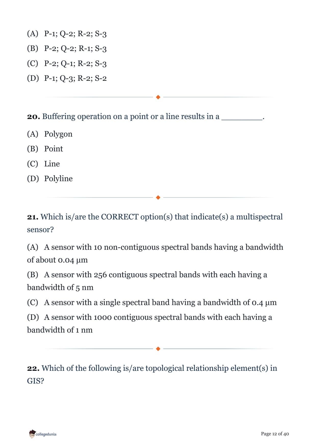
Buffering operation on a point or a line results in a ________.
Which is/are the CORRECT option(s) that indicate(s) a multispectral sensor?
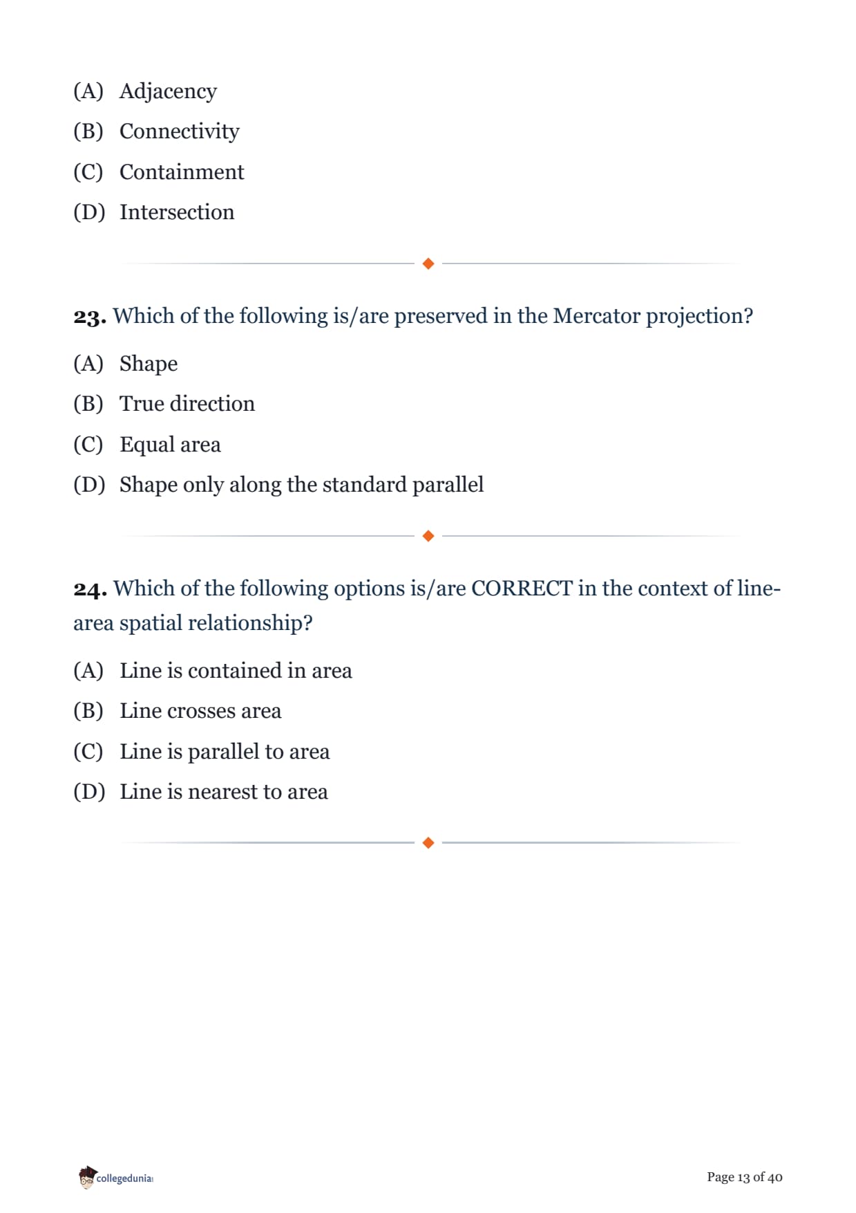
Which of the following is/are topological relationship element(s) in GIS?
Which of the following is/are preserved in the Mercator projection?
Which of the following options is/are CORRECT in the context of line-area spatial relationship?
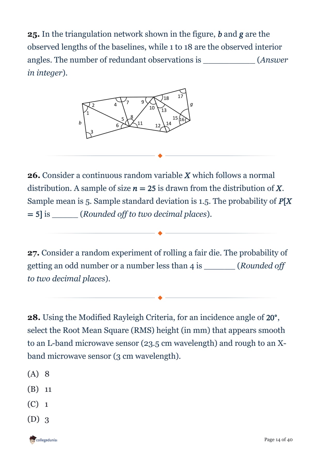
In the triangulation network shown in the figure, \(b\) and \(g\) are the observed lengths of the baselines, while 1 to 18 are the observed interior angles. The number of redundant observations is __________ (Answer in integer).

Consider a continuous random variable \(X\) which follows a normal distribution. A sample of size \(n = 25\) is drawn from the distribution of \(X\). Sample mean is 5. Sample standard deviation is 1.5. The probability of \(P[X = 5]\) is _____ (Rounded off to two decimal places).
Consider a random experiment of rolling a fair die. The probability of getting an odd number or a number less than 4 is ______ (Rounded off to two decimal places).
Using the Modified Rayleigh Criteria, for an incidence angle of \(20^\circ\), select the Root Mean Square (RMS) height (in mm) that appears smooth to an L-band microwave sensor (23.5 cm wavelength) and rough to an X-band microwave sensor (3 cm wavelength).
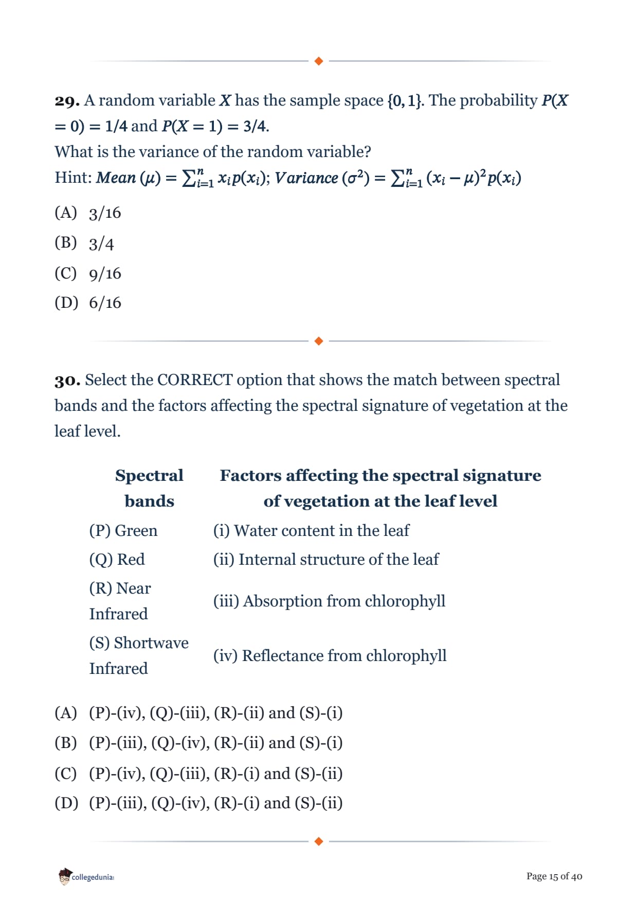
A random variable \(X\) has the sample space \(\{0,1\}\). The probability \(P(X = 0) = 1/4\) and \(P(X = 1) = 3/4\).
What is the variance of the random variable?
Hint: \(Mean\ (\mu) = \sum_{i=1}^{n} x_i p(x_i)\); \(Variance\ (\sigma^2) = \sum_{i=1}^{n} (x_i - \mu)^2 p(x_i)\)
Select the CORRECT option that shows the match between spectral bands and the factors affecting the spectral signature of vegetation at the leaf level.
| Spectral bands | Factors affecting the spectral signature of vegetation at the leaf level |
|---|---|
| (P) Green | (i) Water content in the leaf |
| (Q) Red | (ii) Internal structure of the leaf |
| (R) Near Infrared | (iii) Absorption from chlorophyll |
| (S) Shortwave Infrared | (iv) Reflectance from chlorophyll |
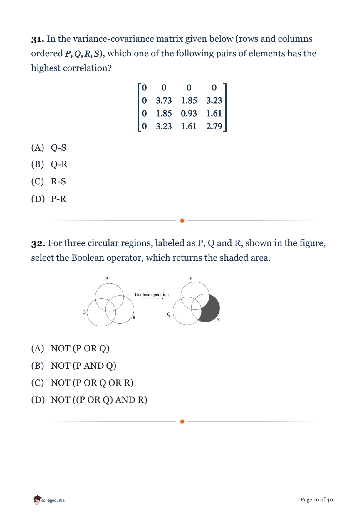
In the variance-covariance matrix given below (rows and columns ordered \(P, Q, R, S\)), which one of the following pairs of elements has the highest correlation?
\[ \begin{bmatrix} 0 & 0 & 0 & 0 \\ 0 & 3.73 & 1.85 & 3.23 \\ 0 & 1.85 & 0.93 & 1.61 \\ 0 & 3.23 & 1.61 & 2.79 \end{bmatrix} \]
For three circular regions, labeled as P, Q and R, shown in the figure, select the Boolean operator, which returns the shaded area.

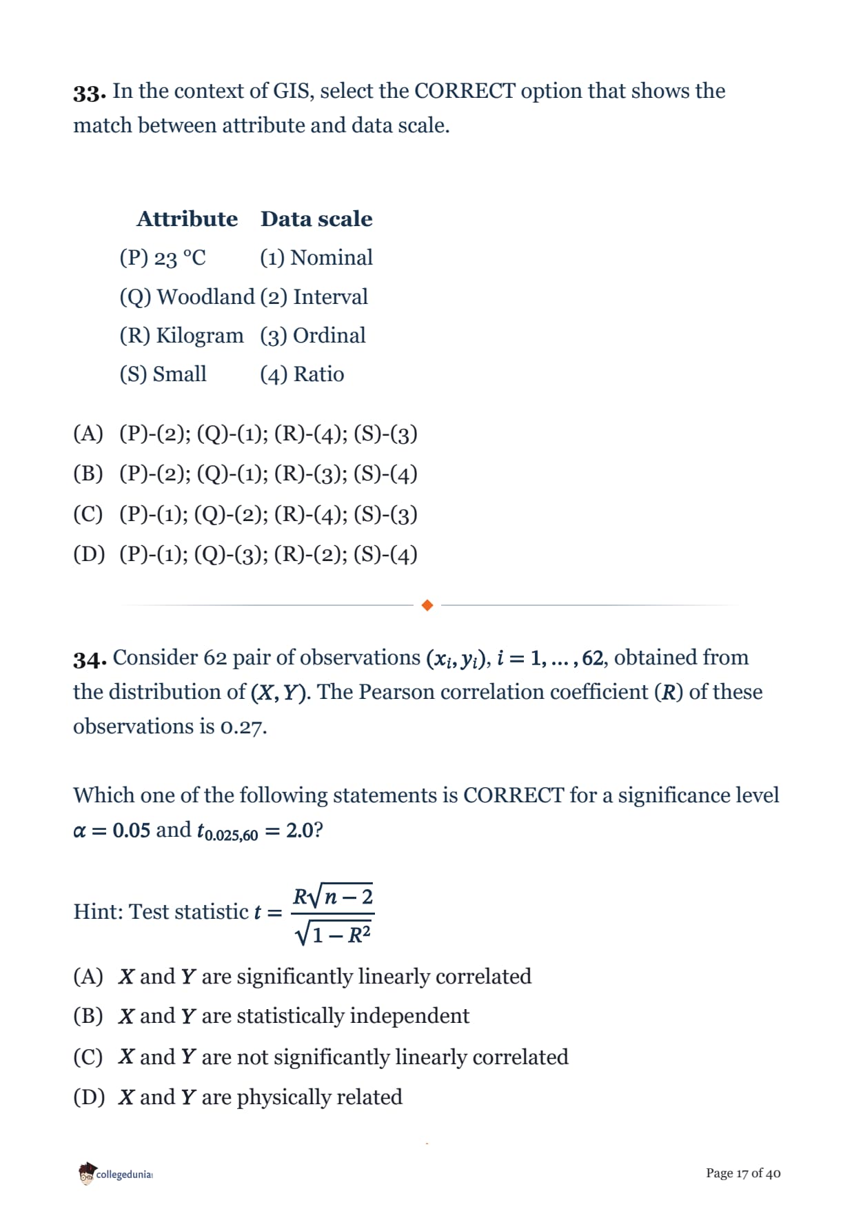
In the context of GIS, select the CORRECT option that shows the match between attribute and data scale.
| Attribute | Data scale |
|---|---|
| (P) 23 °C | (1) Nominal |
| (Q) Woodland | (2) Interval |
| (R) Kilogram | (3) Ordinal |
| (S) Small | (4) Ratio |
Consider 62 pair of observations \((x_i, y_i)\), \(i = 1, \ldots, 62\), obtained from the distribution of \((X, Y)\). The Pearson correlation coefficient (\(R\)) of these observations is 0.27.
Which one of the following statements is CORRECT for a significance level \(\alpha = 0.05\) and \(t_{0.025,60} = 2.0\)?
Hint: Test statistic \( t = \dfrac{R\sqrt{n-2}}{\sqrt{1-R^2}} \)
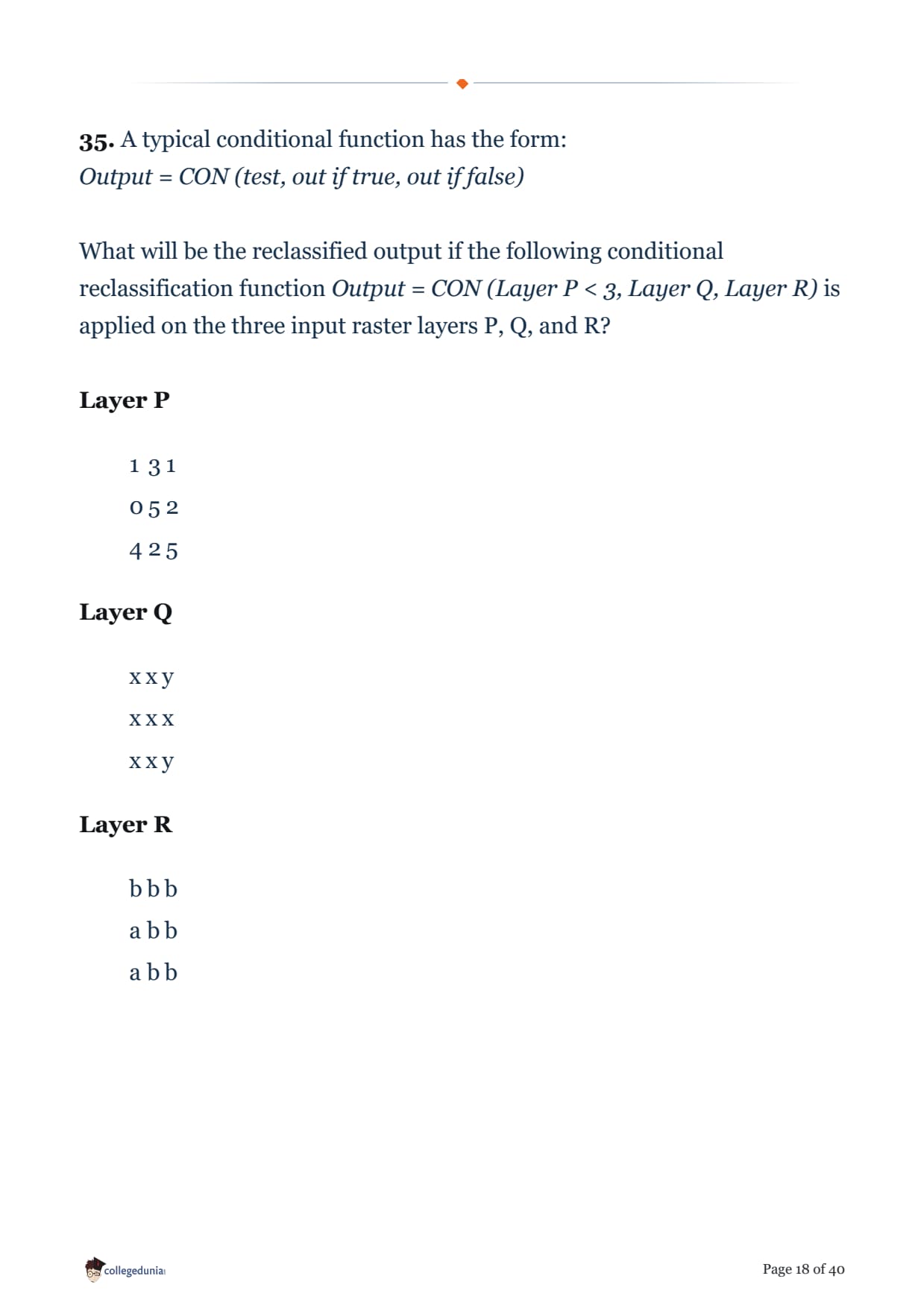
A typical conditional function has the form:
Output = CON (test, out if true, out if false)
What will be the reclassified output if the following conditional reclassification function Output = CON (Layer P < 3, Layer Q, Layer R) is applied on the three input raster layers P, Q, and R?
Layer P
| 1 | 3 | 1 |
| 0 | 5 | 2 |
| 4 | 2 | 5 |
| x | x | y |
| x | x | x |
| x | x | y |
| b | b | b |
| a | b | b |
| a | b | b |
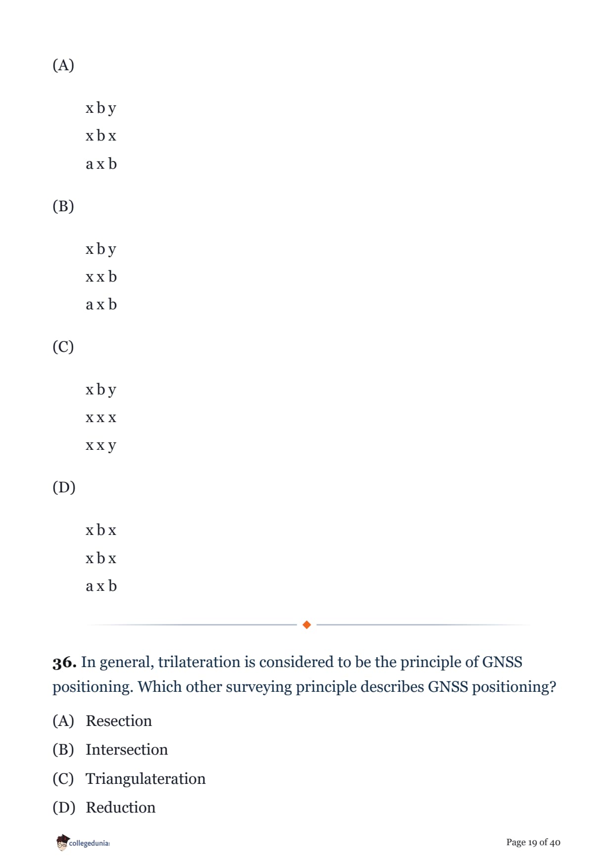
In general, trilateration is considered to be the principle of GNSS positioning. Which other surveying principle describes GNSS positioning?
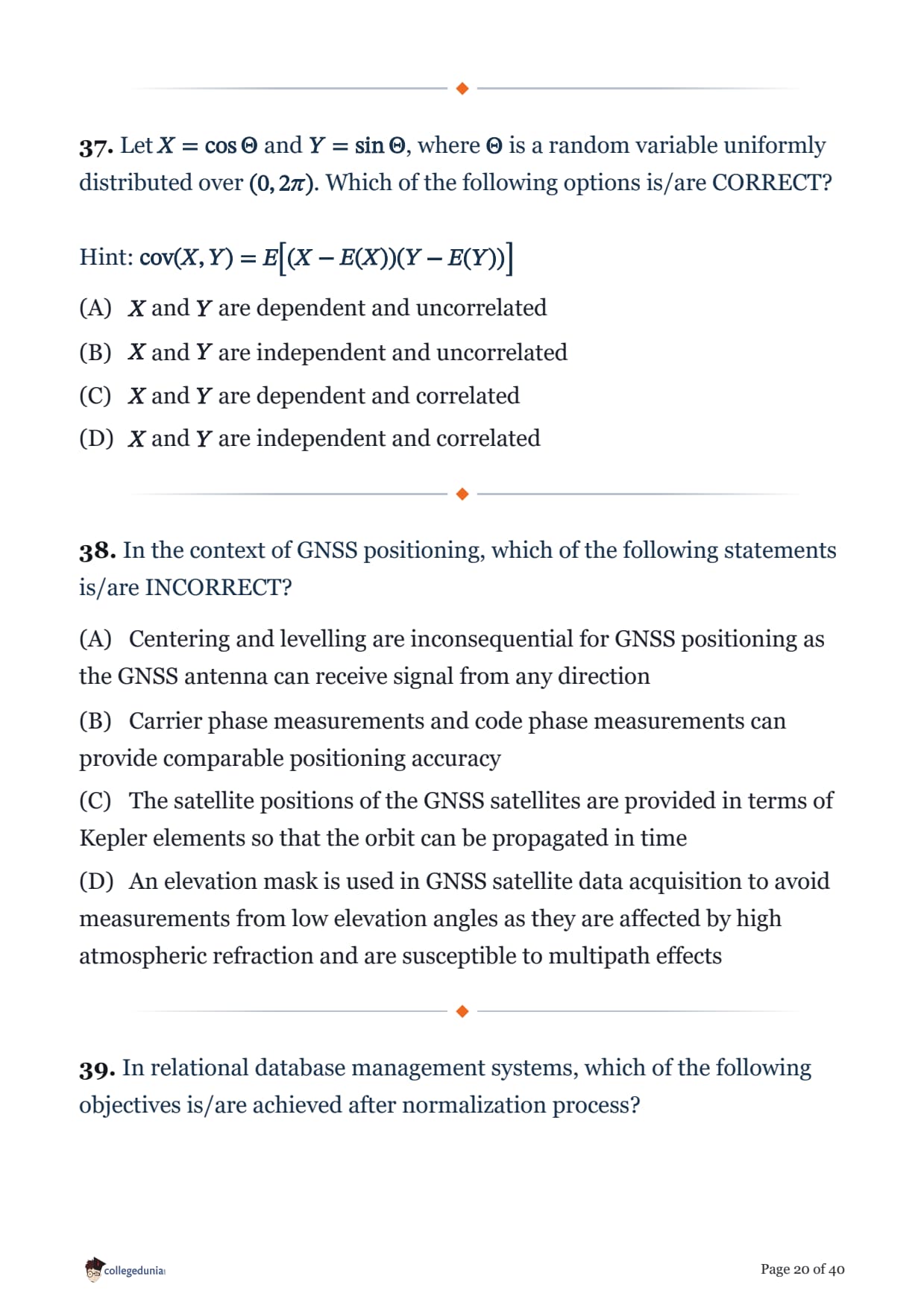
Let \(X = \cos\Theta\) and \(Y = \sin\Theta\), where \(\Theta\) is a random variable uniformly distributed over \((0, 2\pi)\). Which of the following options is/are CORRECT?
Hint: \( \text{cov}(X,Y) = E\big[(X-E(X))(Y-E(Y))\big] \)
In the context of GNSS positioning, which of the following statements is/are INCORRECT?
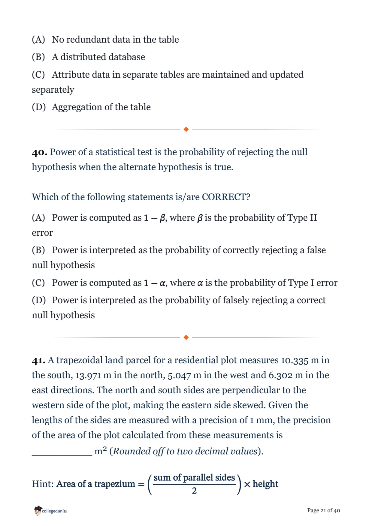
In relational database management systems, which of the following objectives is/are achieved after normalization process?
Power of a statistical test is the probability of rejecting the null hypothesis when the alternate hypothesis is true.
Which of the following statements is/are CORRECT?
A trapezoidal land parcel for a residential plot measures 10.335 m in the south, 13.971 m in the north, 5.047 m in the west and 6.302 m in the east directions. The north and south sides are perpendicular to the western side of the plot, making the eastern side skewed. Given the lengths of the sides are measured with a precision of 1 mm, the precision of the area of the plot calculated from these measurements is __________ m2 (Rounded off to two decimal values).
Hint: \( \text{Area of a trapezium} = \left(\dfrac{\text{sum of parallel sides}}{2}\right) \times \text{height} \)
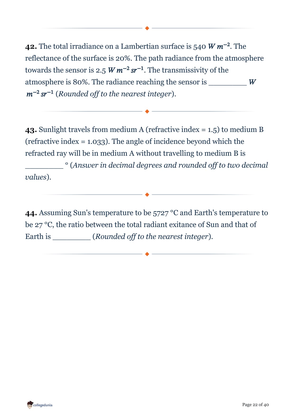
The total irradiance on a Lambertian surface is 540 \(W\,m^{-2}\). The reflectance of the surface is 20%. The path radiance from the atmosphere towards the sensor is 2.5 \(W\,m^{-2}\,sr^{-1}\). The transmissivity of the atmosphere is 80%. The radiance reaching the sensor is ________ \(W\,m^{-2}\,sr^{-1}\) (Rounded off to the nearest integer).
Sunlight travels from medium A (refractive index = 1.5) to medium B (refractive index = 1.033). The angle of incidence beyond which the refracted ray will be in medium A without travelling to medium B is ________ ° (Answer in decimal degrees and rounded off to two decimal values).
Assuming Sun's temperature to be 5727 °C and Earth's temperature to be 27 °C, the ratio between the total radiant exitance of Sun and that of Earth is ________ (Rounded off to the nearest integer).
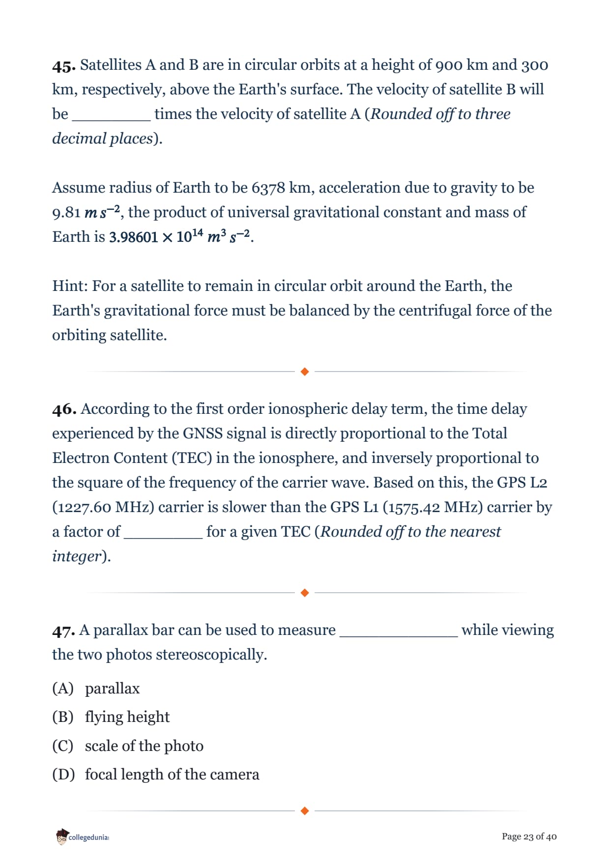
Satellites A and B are in circular orbits at a height of 900 km and 300 km, respectively, above the Earth's surface. The velocity of satellite B will be ________ times the velocity of satellite A (Rounded off to three decimal places).
Assume radius of Earth to be 6378 km, acceleration due to gravity to be 9.81 \(m\,s^{-2}\), the product of universal gravitational constant and mass of Earth is \(3.98601\times10^{14}\ m^3\,s^{-2}\).
Hint: For a satellite to remain in circular orbit around the Earth, the Earth's gravitational force must be balanced by the centrifugal force of the orbiting satellite.
According to the first order ionospheric delay term, the time delay experienced by the GNSS signal is directly proportional to the Total Electron Content (TEC) in the ionosphere, and inversely proportional to the square of the frequency of the carrier wave. Based on this, the GPS L2 (1227.60 MHz) carrier is slower than the GPS L1 (1575.42 MHz) carrier by a factor of ________ for a given TEC (Rounded off to the nearest integer).
A parallax bar can be used to measure ____________ while viewing the two photos stereoscopically.
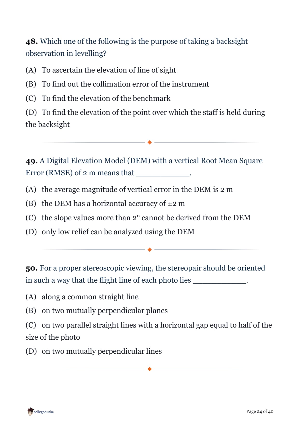
Which one of the following is the purpose of taking a backsight observation in levelling?
A Digital Elevation Model (DEM) with a vertical Root Mean Square Error (RMSE) of 2 m means that ___________.
For a proper stereoscopic viewing, the stereopair should be oriented in such a way that the flight line of each photo lies ___________.
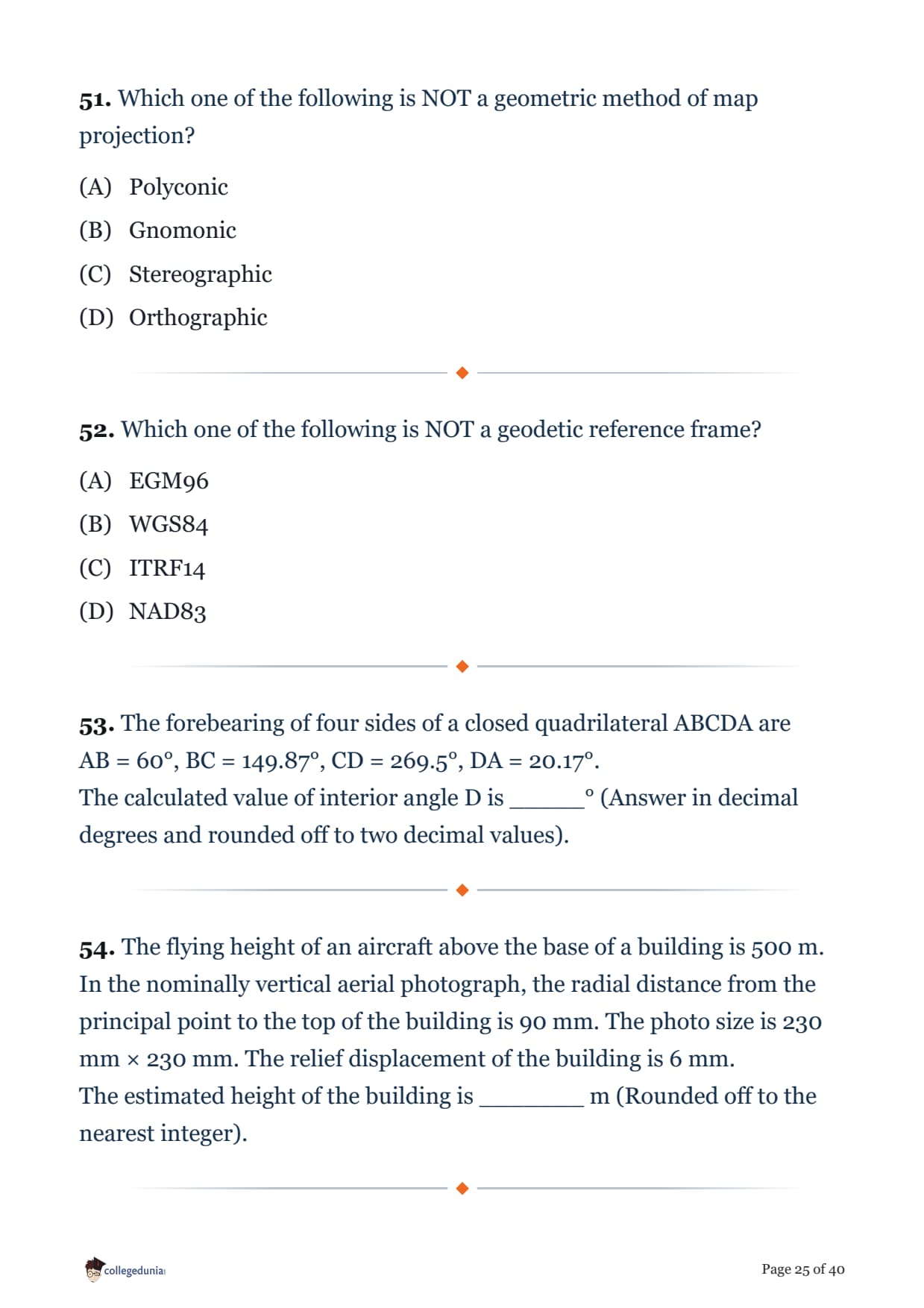
Which one of the following is NOT a geometric method of map projection?
Which one of the following is NOT a geodetic reference frame?
The forebearing of four sides of a closed quadrilateral ABCDA are
AB = 60°, BC = 149.87°, CD = 269.5°, DA = 20.17°.
The calculated value of interior angle D is _____° (Answer in decimal degrees and rounded off to two decimal values).
The flying height of an aircraft above the base of a building is 500 m. In the nominally vertical aerial photograph, the radial distance from the principal point to the top of the building is 90 mm. The photo size is 230 mm × 230 mm. The relief displacement of the building is 6 mm.
The estimated height of the building is _______ m (Rounded off to the nearest integer).
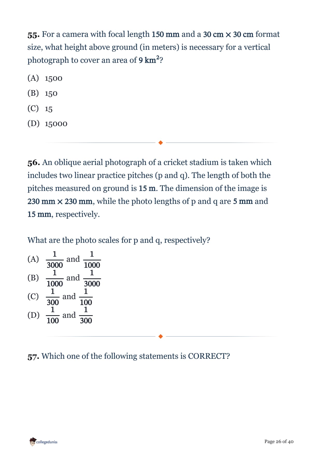
For a camera with focal length \( 150\ \text{mm} \) and a \( 30\ \text{cm} \times 30\ \text{cm} \) format size, what height above ground (in meters) is necessary for a vertical photograph to cover an area of \( 9\ \text{km}^2 \)?
An oblique aerial photograph of a cricket stadium is taken which includes two linear practice pitches (p and q). The length of both the pitches measured on ground is \( 15\ \text{m} \). The dimension of the image is \( 230\ \text{mm} \times 230\ \text{mm} \), while the photo lengths of p and q are \( 5\ \text{mm} \) and \( 15\ \text{mm} \), respectively.
What are the photo scales for p and q, respectively?
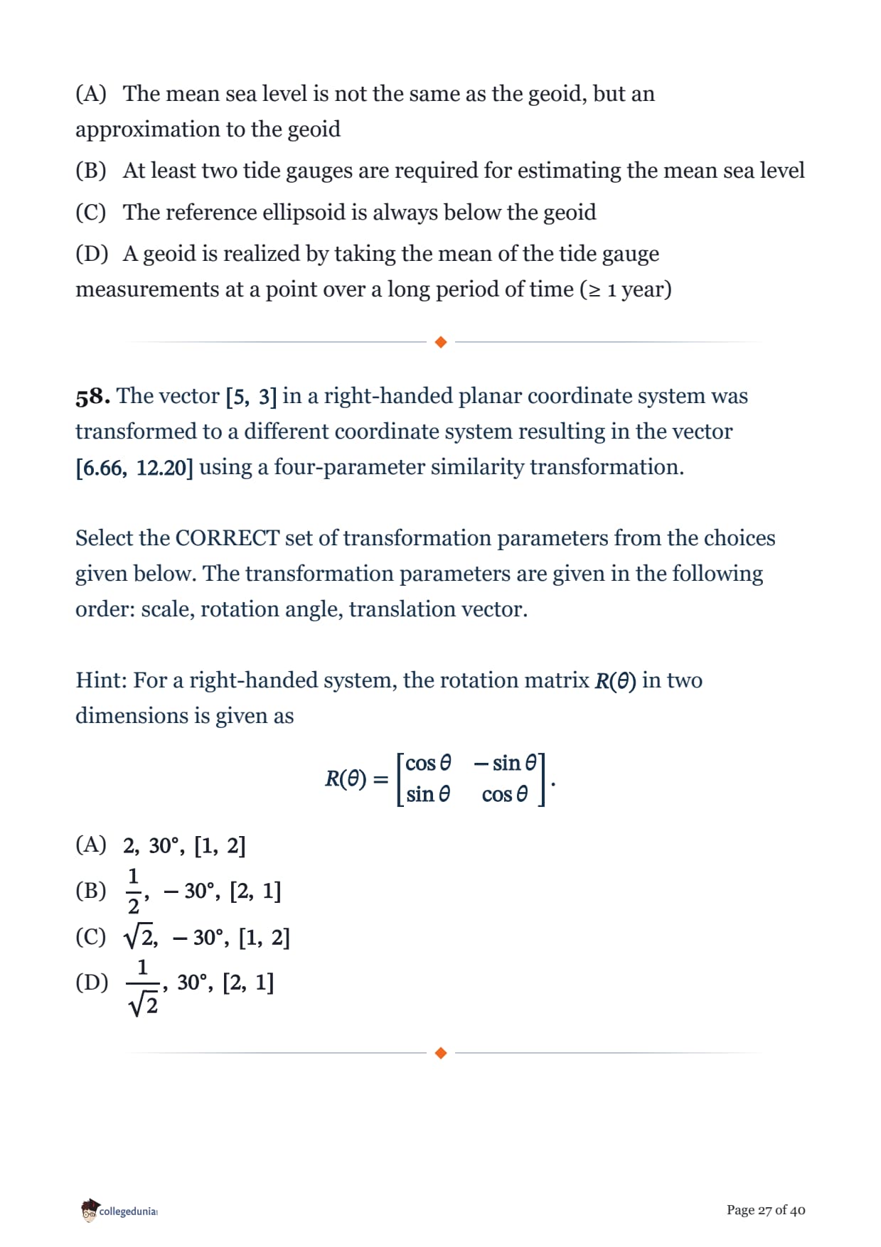
Which one of the following statements is CORRECT?
The vector \( [5,\ 3] \) in a right-handed planar coordinate system was transformed to a different coordinate system resulting in the vector \( [6.66,\ 12.20] \) using a four-parameter similarity transformation.
Select the CORRECT set of transformation parameters from the choices given below. The transformation parameters are given in the following order: scale, rotation angle, translation vector.
Hint: For a right-handed system, the rotation matrix \( R(\theta) \) in two dimensions is given as
\[ R(\theta) = \begin{bmatrix} \cos\theta & -\sin\theta \\ \sin\theta & \cos\theta \end{bmatrix}. \]
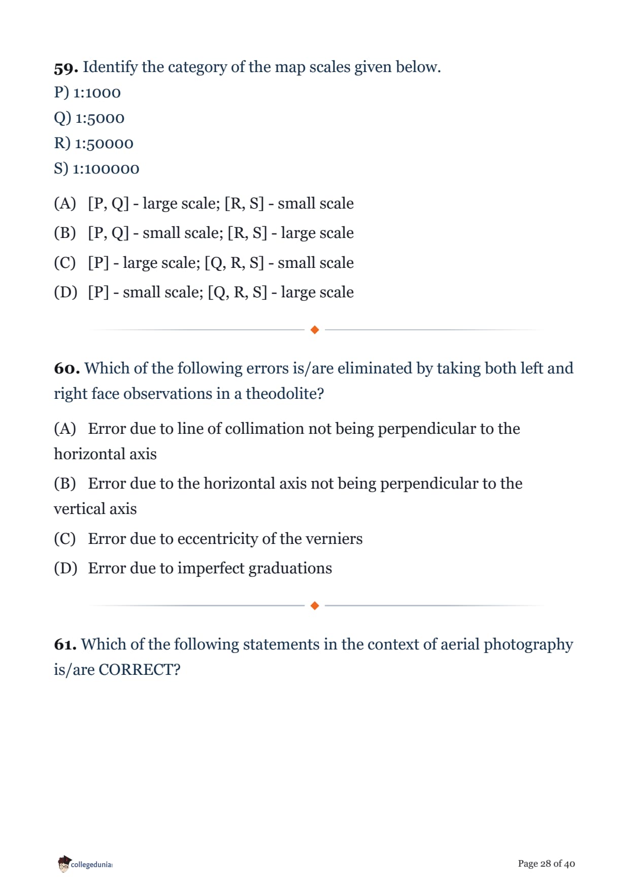
Identify the category of the map scales given below.
P) 1:1000
Q) 1:5000
R) 1:50000
S) 1:100000
Which of the following errors is/are eliminated by taking both left and right face observations in a theodolite?
Which of the following statements in the context of aerial photography is/are CORRECT?
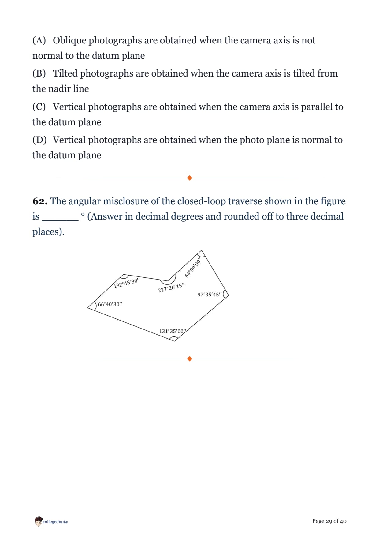
The angular misclosure of the closed-loop traverse shown in the figure is ______ ° (Answer in decimal degrees and rounded off to three decimal places).

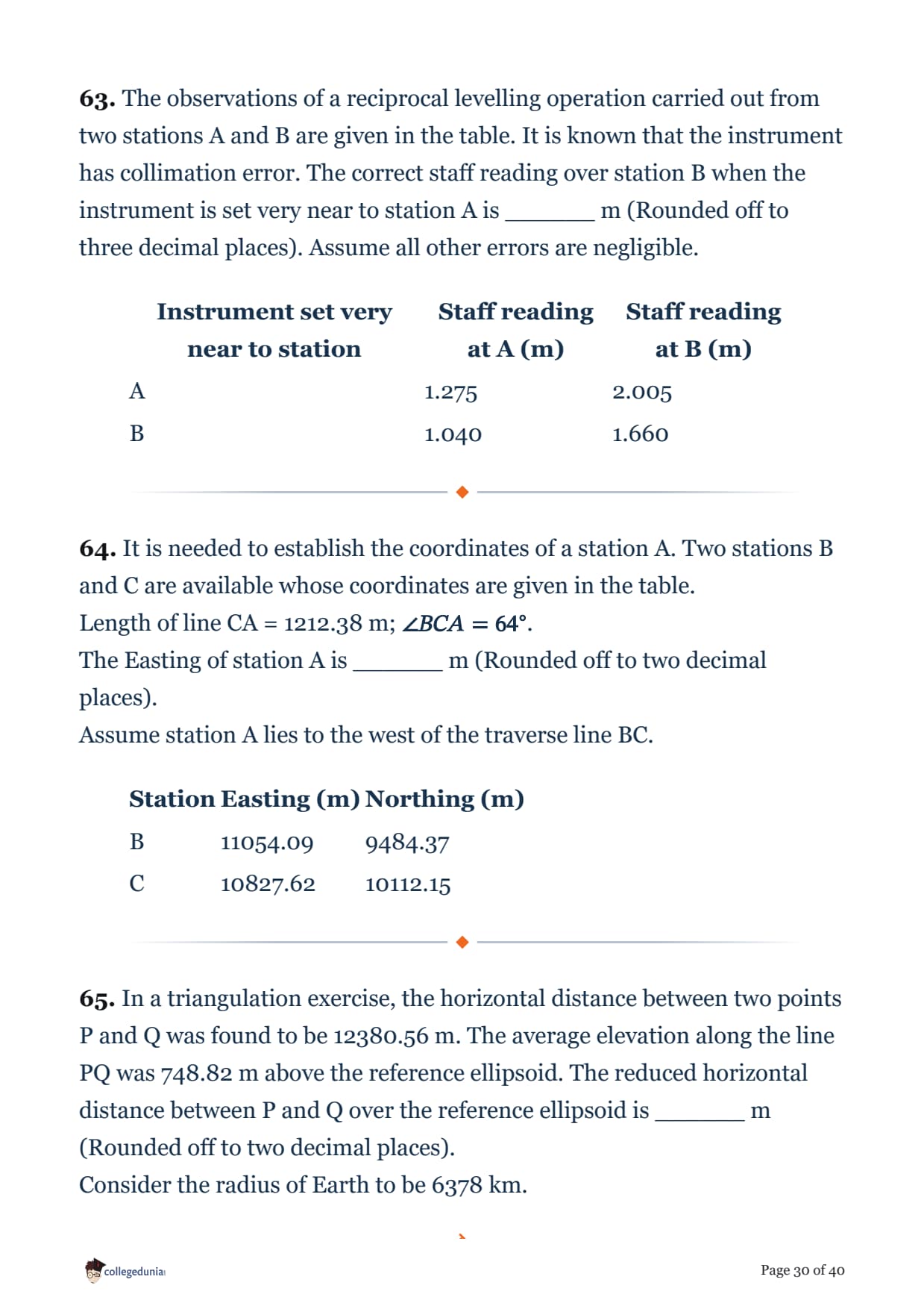
The observations of a reciprocal levelling operation carried out from two stations A and B are given in the table. It is known that the instrument has collimation error. The correct staff reading over station B when the instrument is set very near to station A is ______ m (Rounded off to three decimal places). Assume all other errors are negligible.
| Instrument set very near to station | Staff reading at A (m) | Staff reading at B (m) |
|---|---|---|
| A | 1.275 | 2.005 |
| B | 1.040 | 1.660 |
It is needed to establish the coordinates of a station A. Two stations B and C are available whose coordinates are given in the table.
Length of line CA = 1212.38 m; \(\angle BCA = 64^\circ\).
The Easting of station A is ______ m (Rounded off to two decimal places).
Assume station A lies to the west of the traverse line BC.
| Station | Easting (m) | Northing (m) |
|---|---|---|
| B | 11054.09 | 9484.37 |
| C | 10827.62 | 10112.15 |
In a triangulation exercise, the horizontal distance between two points P and Q was found to be 12380.56 m. The average elevation along the line PQ was 748.82 m above the reference ellipsoid. The reduced horizontal distance between P and Q over the reference ellipsoid is ______ m (Rounded off to two decimal places).
Consider the radius of Earth to be 6378 km.
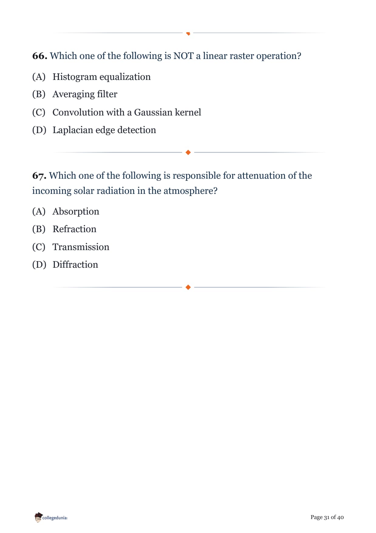
Which one of the following is NOT a linear raster operation?
Which one of the following is responsible for attenuation of the incoming solar radiation in the atmosphere?
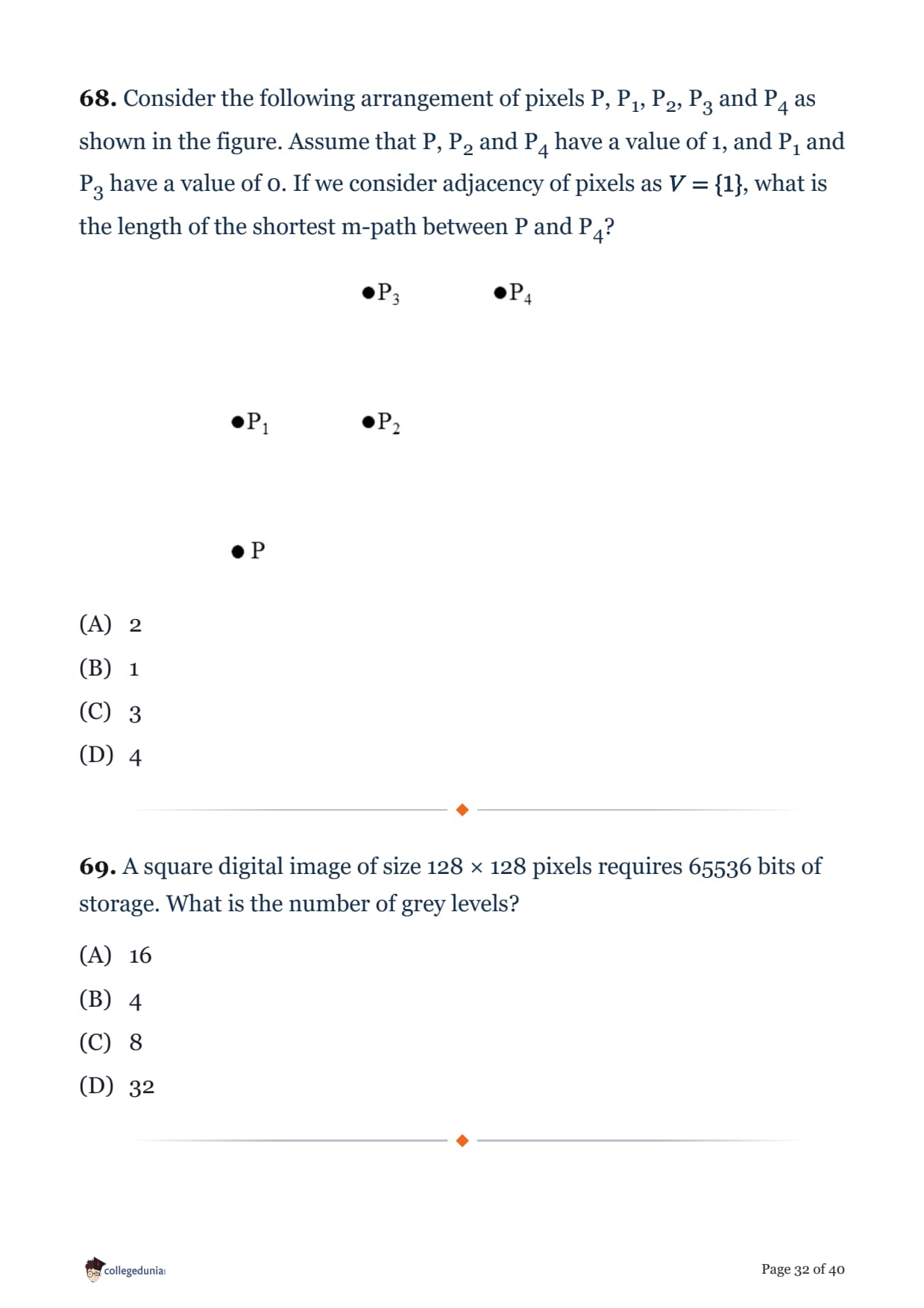
Consider the following arrangement of pixels P, P1, P2, P3 and P4 as shown in the figure. Assume that P, P2 and P4 have a value of 1, and P1 and P3 have a value of 0. If we consider adjacency of pixels as \(V=\{1\}\), what is the length of the shortest m-path between P and P4?

A square digital image of size 128 × 128 pixels requires 65536 bits of storage. What is the number of grey levels?
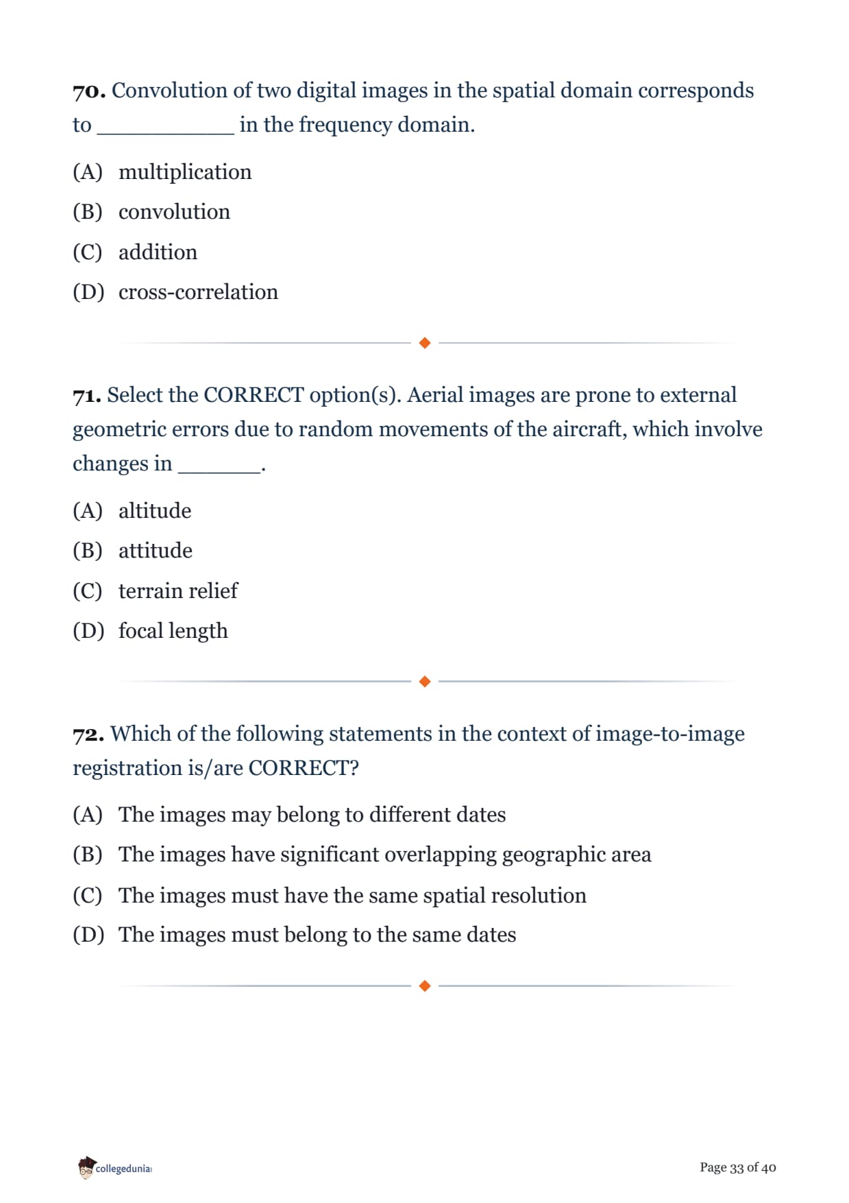
Convolution of two digital images in the spatial domain corresponds to __________ in the frequency domain.
Select the CORRECT option(s). Aerial images are prone to external geometric errors due to random movements of the aircraft, which involve changes in ______.
Which of the following statements in the context of image-to-image registration is/are CORRECT?

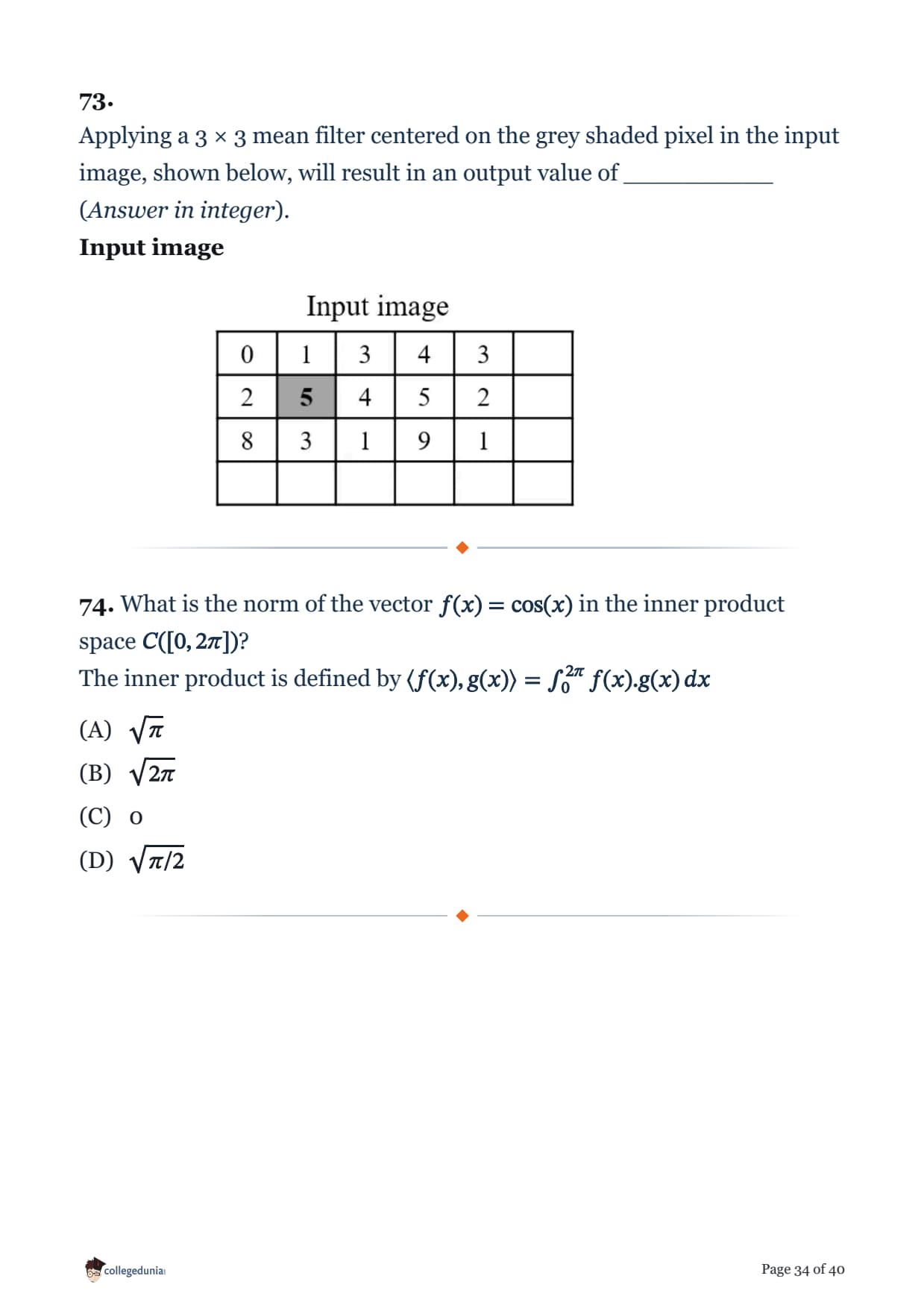
What is the norm of the vector \(f(x) = \cos(x)\) in the inner product space \(C([0, 2\pi])\)?
The inner product is defined by \(\langle f(x), g(x)\rangle = \int_0^{2\pi} f(x).g(x)\,dx\)
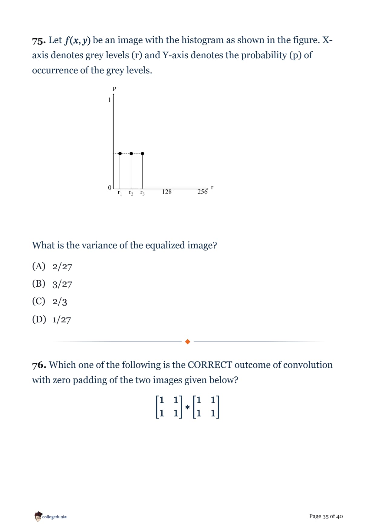
Let \(f(x,y)\) be an image with the histogram as shown in the figure. X-axis denotes grey levels (r) and Y-axis denotes the probability (p) of occurrence of the grey levels.

What is the variance of the equalized image?
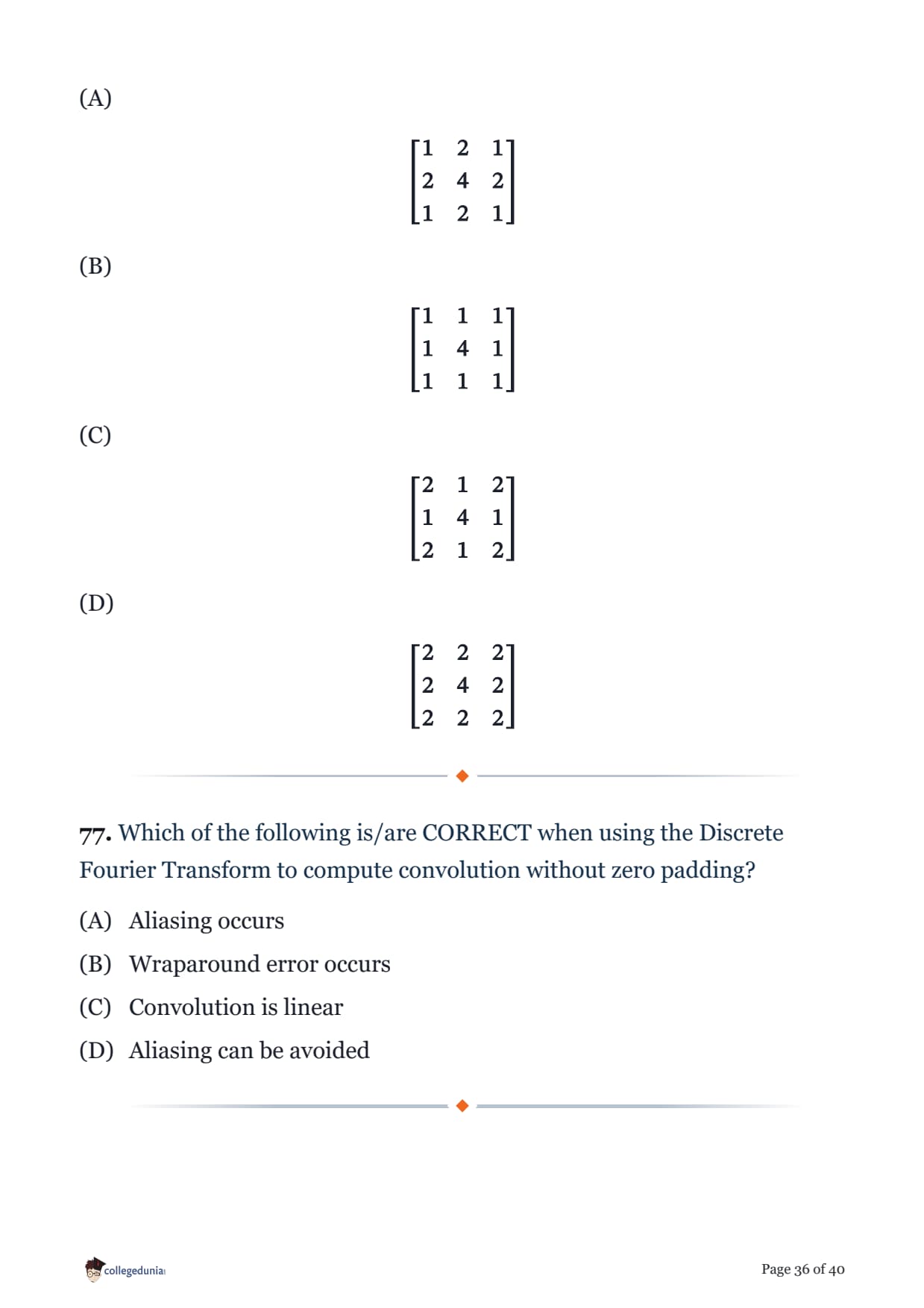
Which one of the following is the CORRECT outcome of convolution with zero padding of the two images given below?
\[ \begin{bmatrix} 1 & 1 \\ 1 & 1 \end{bmatrix} * \begin{bmatrix} 1 & 1 \\ 1 & 1 \end{bmatrix} \]
Which of the following is/are CORRECT when using the Discrete Fourier Transform to compute convolution without zero padding?
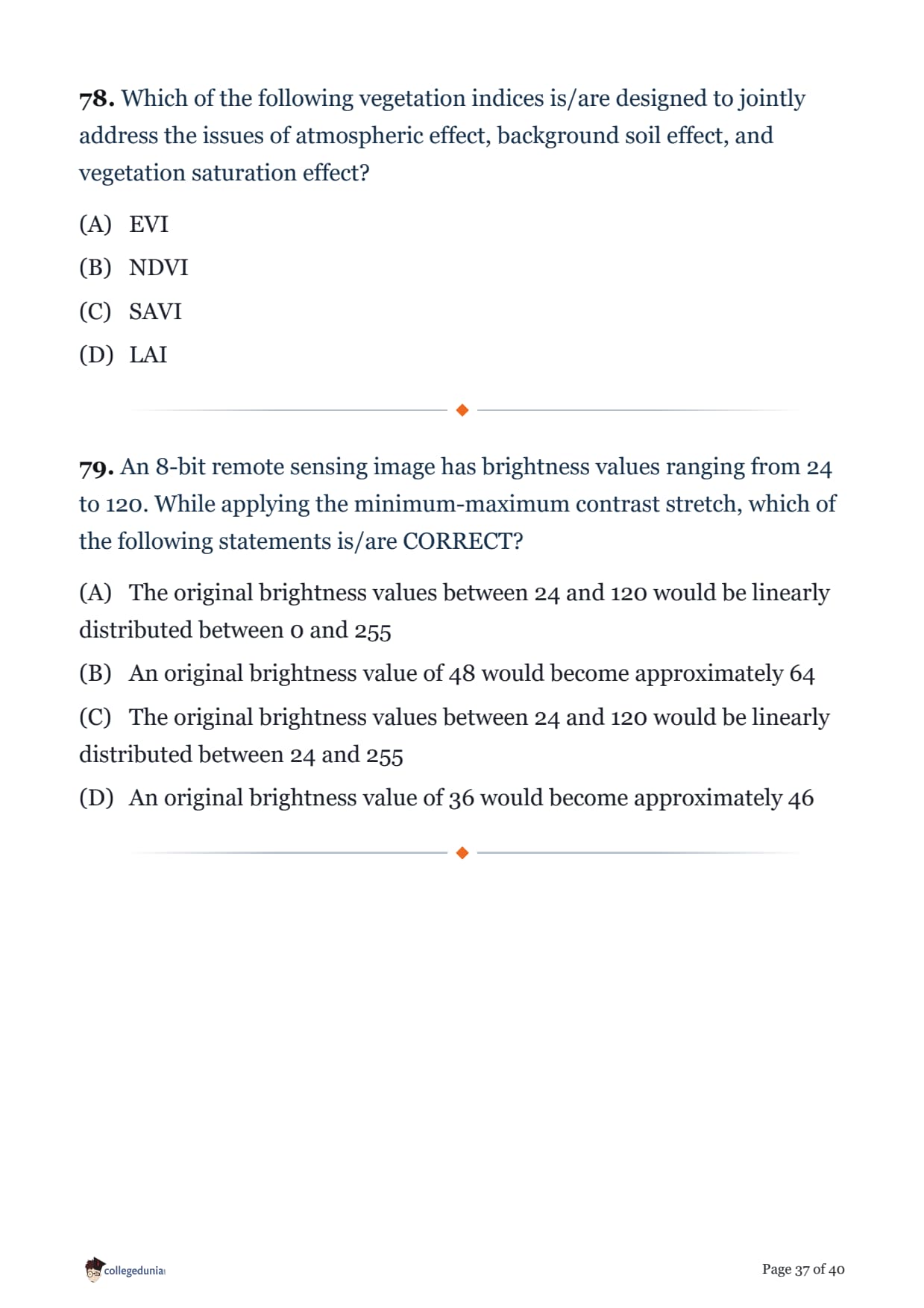
Which of the following vegetation indices is/are designed to jointly address the issues of atmospheric effect, background soil effect, and vegetation saturation effect?
An 8-bit remote sensing image has brightness values ranging from 24 to 120. While applying the minimum-maximum contrast stretch, which of the following statements is/are CORRECT?
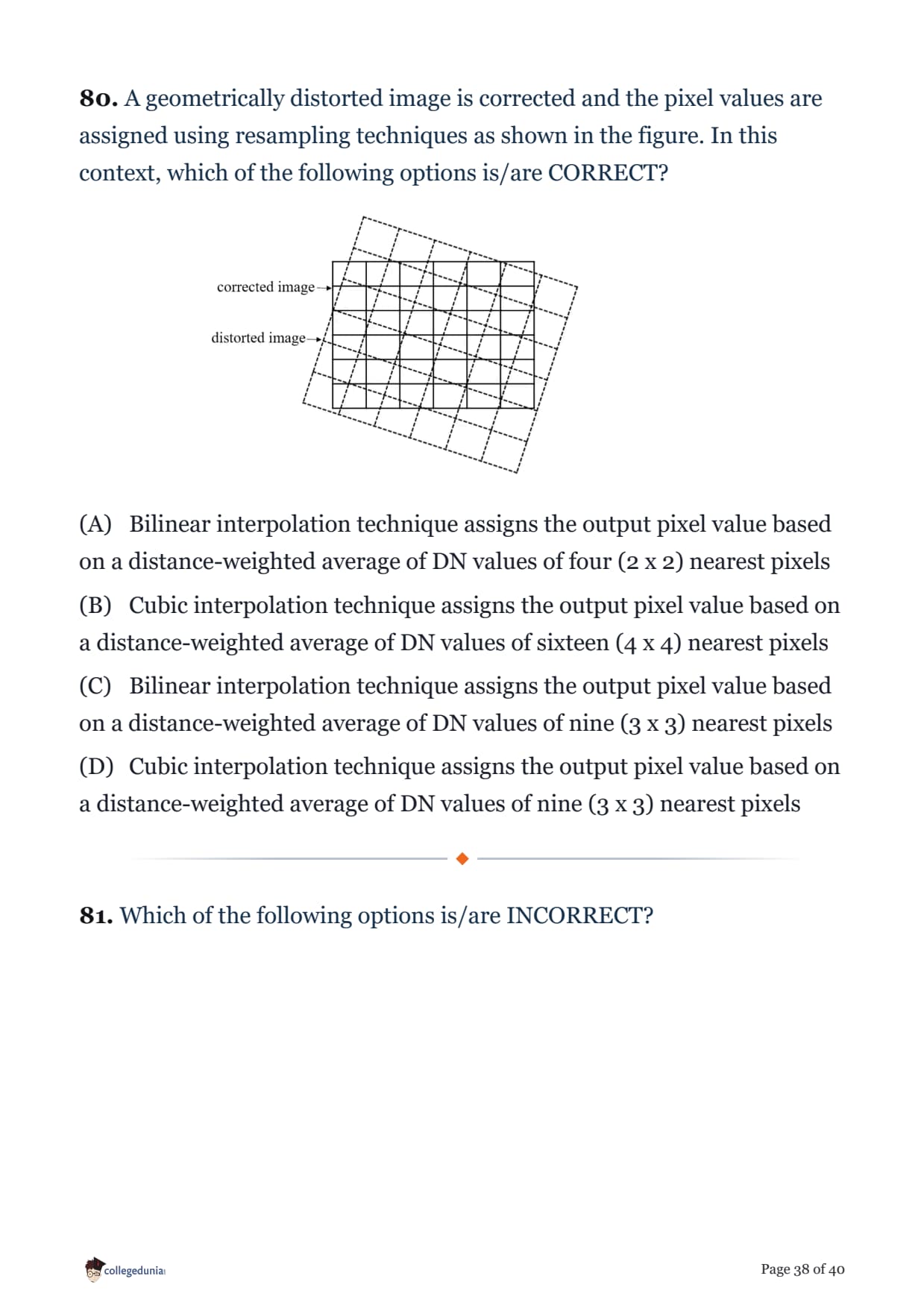
A geometrically distorted image is corrected and the pixel values are assigned using resampling techniques as shown in the figure. In this context, which of the following options is/are CORRECT?

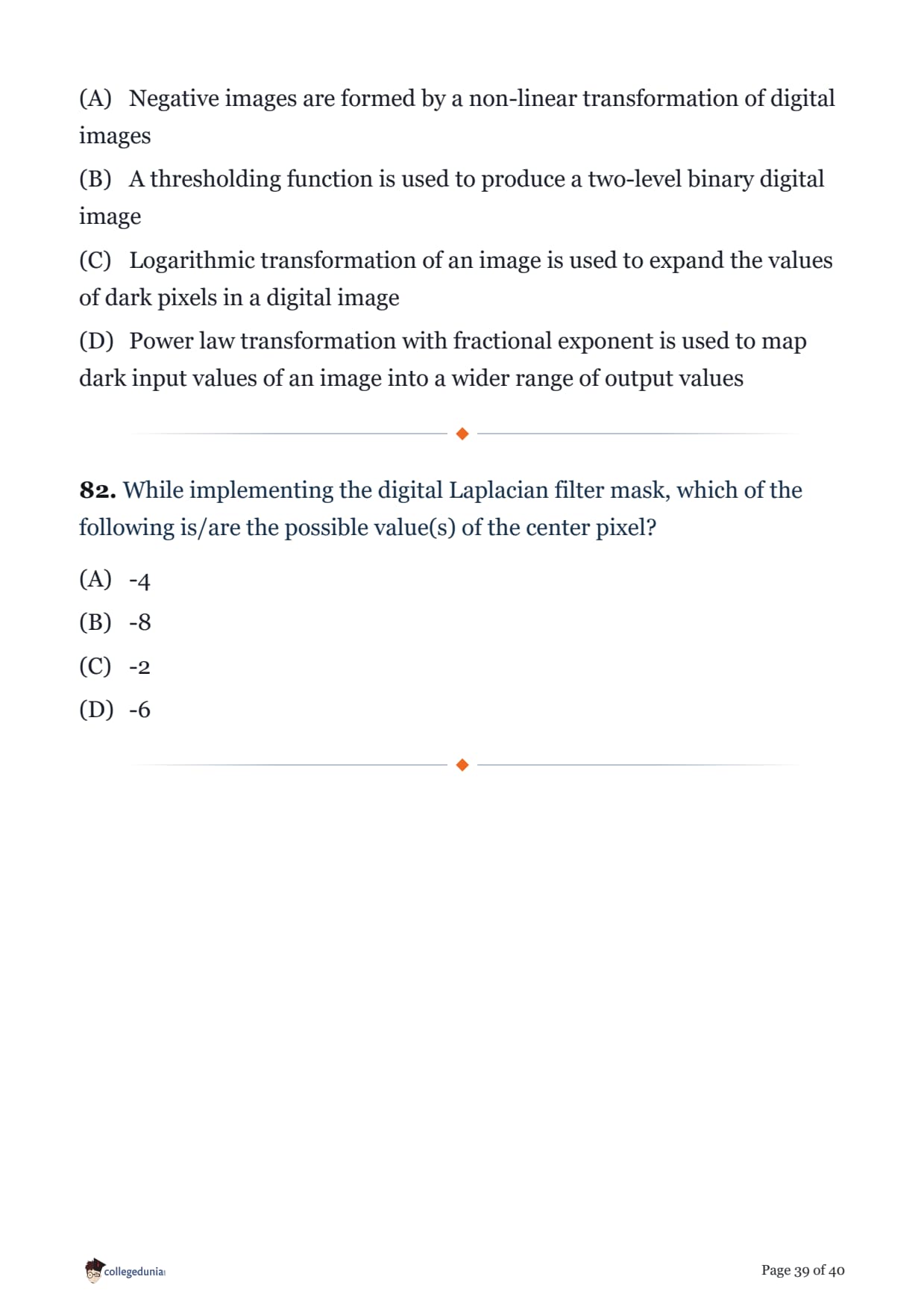
Which of the following options is/are INCORRECT?
While implementing the digital Laplacian filter mask, which of the following is/are the possible value(s) of the center pixel?
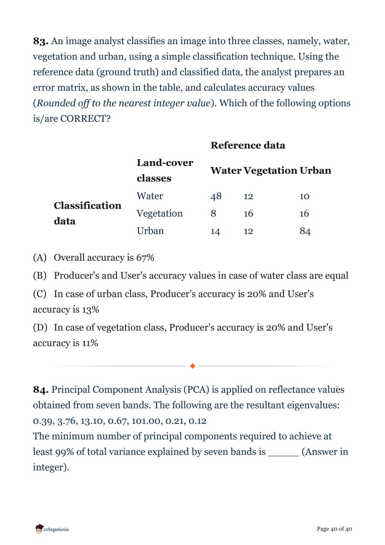
An image analyst classifies an image into three classes, namely, water, vegetation and urban, using a simple classification technique. Using the reference data (ground truth) and classified data, the analyst prepares an error matrix, as shown in the table, and calculates accuracy values (Rounded off to the nearest integer value). Which of the following options is/are CORRECT?
| Reference data | ||||
| Land-cover classes | Water | Vegetation | Urban | |
| Classification data | Water | 48 | 12 | 10 |
| Vegetation | 8 | 16 | 16 | |
| Urban | 14 | 12 | 84 | |
Principal Component Analysis (PCA) is applied on reflectance values obtained from seven bands. The following are the resultant eigenvalues:
0.39, 3.76, 13.10, 0.67, 101.00, 0.21, 0.12
The minimum number of principal components required to achieve at least 99% of total variance explained by seven bands is _____ (Answer in integer).
GATE 2026 Geomatics Engineering Exam Pattern and Marking Scheme Explained
As per the IIT Guwahati master paper on the official website (gate2026.iitg.ac.in), the GE paper mixes General Aptitude, Engineering Mathematics, and the Geomatics core, with a compulsory Part A and an optional Part B.
- Total questions: 65 questions attempted (the master paper prints 84, since Part B has two optional sections and you attempt only one)
- Duration: 3 hours for the full computer-based test
- Total marks: 100 - General Aptitude 15, Engineering Mathematics 13, and the Geomatics core 72
- Marking scheme: 1-mark and 2-mark questions, with negative marking on MCQs only (1/3 and 2/3), and no negative marking on MSQ or NAT
- Question types: MCQ (single correct), MSQ (multiple select), and NAT (numerical answer type)
High-Weightage Subjects in GATE 2026 Geomatics Engineering to Focus On First
Going by the actual GATE 2026 GE master paper, the marks were spread across eight core areas, and remote sensing and image processing carried the most questions.
- Remote Sensing: the single biggest block with about 15 questions, covering spectral signatures, radiance, vegetation indices, and accuracy assessment
- Image Processing: around 12 questions on convolution, histogram equalization, filtering, and resampling
- Surveying and Geodesy: about 11 questions on levelling, traverse computation, and coordinate geometry
- GIS: roughly 8 questions on topology, buffering, spatial relationships, and map algebra
- GNSS and Photogrammetry: about 7 questions each on carrier phase, dilution of precision, photo scale, and relief displacement
- Engineering Mathematics: around 7 questions on probability, correlation, and hypothesis testing
GATE 2026 Geomatics Engineering Question Paper Analysis Video
Source: Geomatics Engineering
How to Use the GATE 2026 Geomatics Engineering Question Paper for Practice
Treat the paper as a timed mock first, then review every question against the solution PDF and redo the sets where you lost marks.
- Attempt all 65 questions in one 3-hour sitting before you look at any answer, so you feel the real time pressure
- Use the solution PDF to check the NAT questions carefully - many, like the traverse misclosure and the Sun-to-Earth exitance ratio, need full working, not just the final value
- Focus on Remote Sensing, Image Processing, and Surveying first, since together they made up more than half the paper
- Redo the Part B section you did not attempt in the exam - both Section I and Section II are solved here, so you cover the whole master paper
GATE 2026 Geomatics Engineering Question Paper FAQs
Ques. Is the GATE 2026 Geomatics Engineering question paper available with solutions?
Ans. Yes. You can download the full GATE 2026 Geomatics Engineering question paper and its detailed step-by-step solutions from the table above. All 84 questions from the master paper, including both Part B optional sections, are solved.
Ques. Which topics had the highest weightage in GATE 2026 Geomatics Engineering?
Ans. Remote Sensing dominated with about 15 questions, followed by Image Processing with around 12 and Surveying and Geodesy with about 11. GIS, GNSS, and Photogrammetry together added roughly 22 more, so these six areas decided the paper.
Ques. What is the exam pattern and marking scheme for GATE Geomatics Engineering 2026?
Ans. The GE paper has 65 questions for 100 marks in 3 hours, split as General Aptitude 15, Engineering Mathematics 13, and Geomatics core 72. It uses 1-mark and 2-mark MCQ, MSQ, and NAT questions, with negative marking only on the MCQs.
Ques. How many questions are in the GATE Geomatics Engineering master paper and why does it show 84?
Ans. A candidate attempts 65 questions, but the master paper prints 84 because Part B has two optional sections (Section I and Section II) and you answer only one. Our solutions cover all 84 so you can practise both.
Ques. Where can I download the GATE 2026 Geomatics Engineering question paper with solutions PDF for free?
Ans. Use the Download PDF and Check Solutions links in the table above on Collegedunia for the free question paper and full solutions. The official master question paper and answer key are on the IIT Guwahati site at gate2026.iitg.ac.in.
Ques. Was there negative marking in the GATE 2026 Geomatics Engineering paper?
Ans. Negative marking applied only to MCQs - one third of a mark off for a wrong 1-mark MCQ and two thirds for a wrong 2-mark MCQ. MSQ and NAT questions had no negative marking, so it was safe to attempt every numerical question.



Comments