


CUET PG Geography Question Paper 2025 is available here for download. NTA is conducting CUET PG 2025 Geography on 15 March 2025 in shift 3 from 4.00 PM - 05.30 PM. As per the revised exam pattern, candidates get 90 minutes to solve 75 MCQs in the CUET PG 2025 Geography question paper. The CUET PG 2025 Geography exam is expected to be of moderate to high difficulty, based on past trends and syllabus coverage.
CUET PG Geography Question Paper 2025 PDF Download
| CUET PG Geography Question Paper with Answer Key |
|
Check Solution |

CUET PG 2025 Geography Questions with Solutions
Question 1.
Which type of pollution results in Acid Rain?
View Solution
The main causes of acid rain are the presence of Sulphur dioxide (SO$_2$) and Nitrogen oxides (NO$_x$) in the atmosphere. These pollutants are primarily released from industrial processes, vehicle emissions, and the burning of fossil fuels. When they combine with water vapor in the atmosphere, they form sulfuric acid and nitric acid, which then fall to the earth as acid rain.Question 2.
What is the term used for pre-monsoon rainfall in Kerala and its neighbouring regions?
View Solution
The pre-monsoon rainfall in Kerala and its neighbouring regions is commonly known as Mango showers. These showers occur before the onset of the southwest monsoon and are named after their association with the ripening of mangoes in the region. These showers help to lower temperatures and are crucial for the agricultural cycle, particularly for mango cultivation.Question 3.
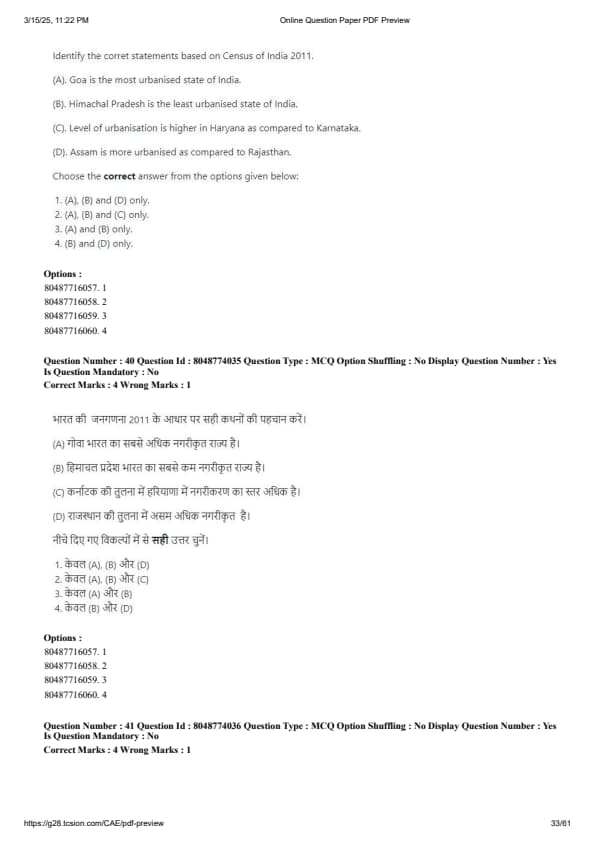
According to the 2011 census, how is urbanisation distributed across Indian states?
View Solution
Urbanization in India, according to the 2011 census, is unevenly distributed across the states. States like Maharashtra, Tamil Nadu, and Gujarat exhibit high levels of urbanization due to their industrial growth, economic development, and better infrastructure. On the other hand, states in the northern and eastern parts of India, like Bihar and Uttar Pradesh, have lower levels of urbanization due to various socio-economic factors.Which region experiences the highest tidal range?
View Solution
The region that experiences the highest tidal range is the Bay of Fundy, located between the Canadian provinces of New Brunswick and Nova Scotia. The tidal range in this area can reach up to 16 meters, making it the highest in the world. This phenomenon is caused by the unique geography of the bay, which amplifies the tidal effect.Who coined the term 'Ecosystem'?
View Solution
The term 'Ecosystem' was coined by A.G. Tansley in 1935. Tansley defined the ecosystem as a system formed by the interaction of a community of organisms with their physical environment. This concept laid the foundation for the study of ecology and the understanding of how organisms and their environments function as a whole.Question 6.
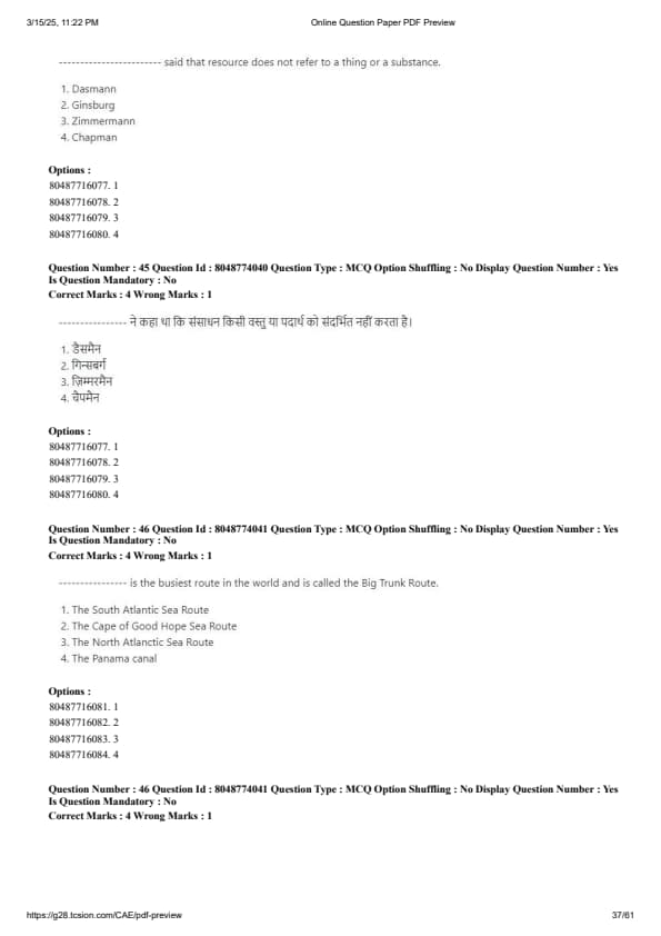
View Solution
The North Atlantic Route is known as the "Big Trunk Route" and is considered the busiest shipping route in the world. This route connects the eastern United States with Western Europe and handles a significant portion of global trade, particularly in terms of containerized goods.Question 7.
Which country is the world's leading producer of manganese?
View Solution
South Africa is the world's leading producer of manganese. The country holds vast reserves of manganese, which are primarily mined in the Northern Cape province. Manganese is a crucial metal used in the production of steel, making South Africa a key player in the global manganese market.Question 8.
In which region is specific humidity the highest?
View Solution
The region where specific humidity is the highest is the Equatorial region. This is due to the consistently high temperatures and abundant moisture in the atmosphere. The equator experiences high evaporation rates due to intense solar heating, and the warm air holds more moisture, resulting in high specific humidity. This is why tropical rainforests, found in the equatorial zone, are so lush and wet.Question 9.
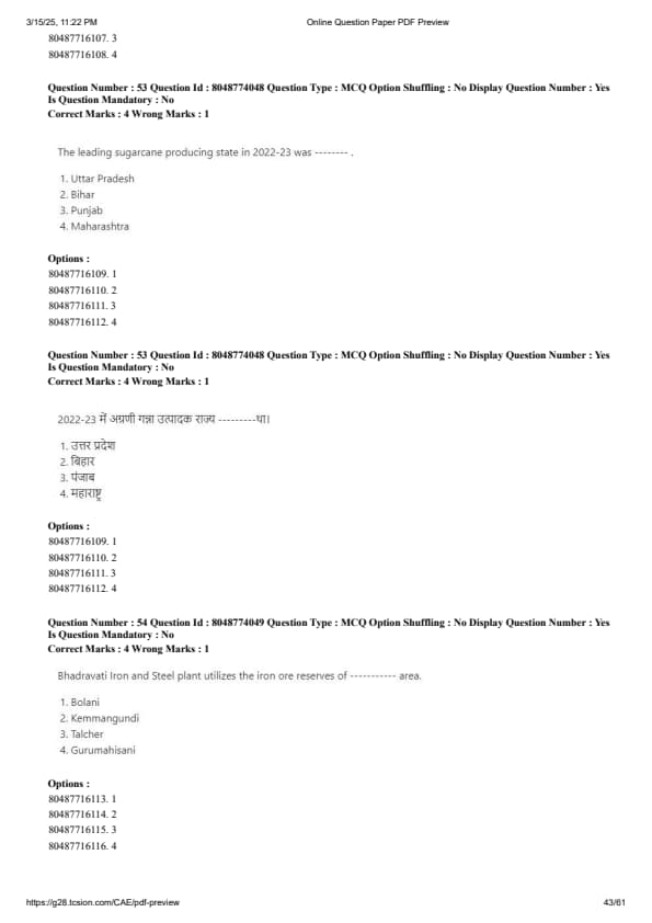
Where does the Bhadravati Iron and Steel Plant (Visvesvaraya Iron and Steel Limited) source its ores from?
View Solution
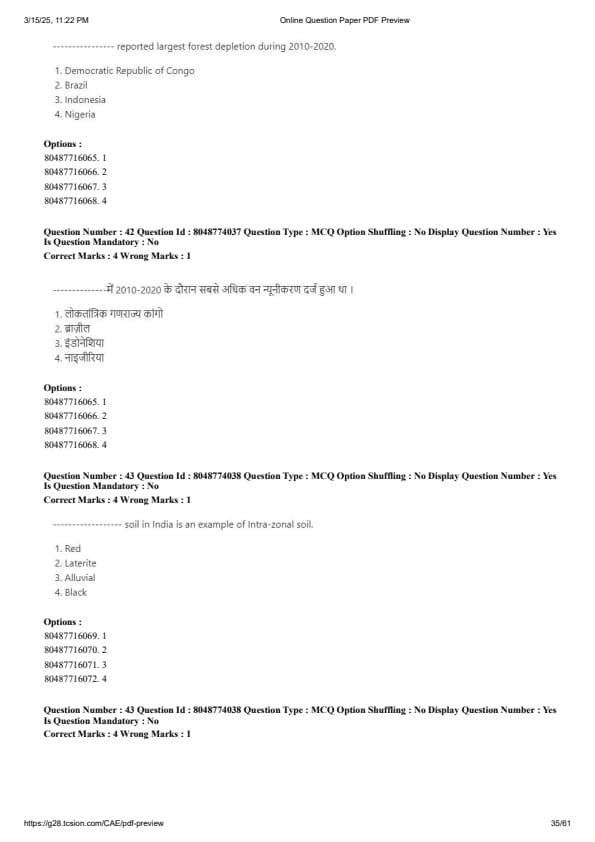
The Bhadravati Iron and Steel Plant (Visvesvaraya Iron and Steel Limited) sources its ores from Kemmangundi, Karnataka. Kemmangundi is known for its rich deposits of iron ore, which are used in the production of high-quality steel at the Bhadravati plant. The region is strategically important for the plant's operations, as it provides easy access to raw materials necessary for steel production.Which country experienced the largest forest depletion between 2010 and 2020?
View Solution
Brazil experienced the largest forest depletion between 2010 and 2020. Deforestation in the Amazon rainforest, a critical global carbon sink, has been driven by activities such as logging, agricultural expansion, and illegal land clearing. The depletion of forests in Brazil has raised concerns about biodiversity loss, climate change, and the disruption of indigenous communities.

Comments