




About 15 to 20 marks of the Class 10 Social Science board paper come from Geography, and Resources and Development is the opening chapter.
Chapter1ResourcesandDevelopmentSolutions.pdf?page=1&dpi=150)
Chapter1ResourcesandDevelopmentSolutions.pdf?page=2&dpi=150)
Chapter1ResourcesandDevelopmentSolutions.pdf?page=3&dpi=150)
Chapter1ResourcesandDevelopmentSolutions.pdf?page=4&dpi=150)
Chapter1ResourcesandDevelopmentSolutions.pdf?page=5&dpi=150)
Chapter1ResourcesandDevelopmentSolutions.pdf?page=6&dpi=150)
Chapter1ResourcesandDevelopmentSolutions.pdf?page=7&dpi=150)
Chapter1ResourcesandDevelopmentSolutions.pdf?page=8&dpi=150)
Chapter1ResourcesandDevelopmentSolutions.pdf?page=9&dpi=150)
Chapter1ResourcesandDevelopmentSolutions.pdf?page=10&dpi=150)
Chapter1ResourcesandDevelopmentSolutions.pdf?page=11&dpi=150)
Chapter1ResourcesandDevelopmentSolutions.pdf?page=12&dpi=150)
Chapter1ResourcesandDevelopmentSolutions.pdf?page=13&dpi=150)
Chapter1ResourcesandDevelopmentSolutions.pdf?page=14&dpi=150)
Chapter1ResourcesandDevelopmentSolutions.pdf?page=15&dpi=150)
The NCERT Solutions for Class 10 Geography Chapter 1 Resources and Development answer every exercise question, as per the 2026-27 CBSE syllabus. Each answer names the soil types, land-use categories and conservation methods.
- 9 NCERT questions solved: 3 MCQs, 3 short-answer (30 words), 2 long-answer (120 words) and 1 puzzle.
- This chapter is a regular source of 1, 3 and 5 mark questions in the board paper.
- Free PDF download in Normal and HD, plus a Hindi-medium read.
Every answer is written by Collegedunia subject experts, checked against the 2026-27 NCERT textbook, and refined using the last five years of CBSE board papers.
What This Class 10 Geography Chapter Covers for the Boards
This chapter explains how anything in our environment becomes a resource only when it is technologically accessible, economically feasible and culturally acceptable. It then teaches you to classify resources, read India's land-use pattern and name the major soil types.
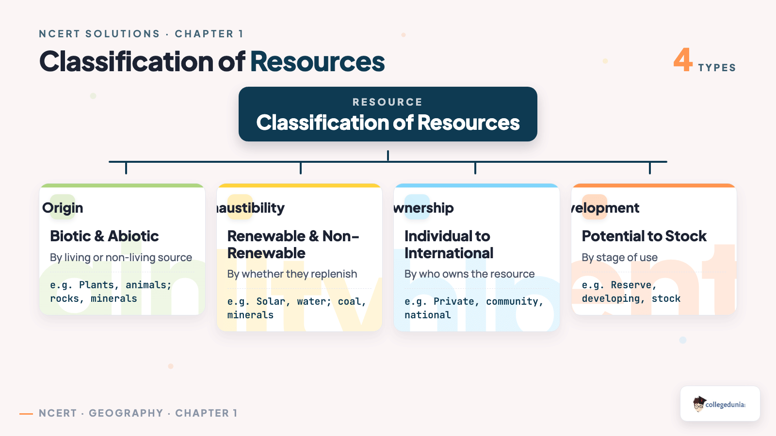
- Classification of resources: by origin, exhaustibility, ownership and stage of development.
- Resource planning and sustainable development: why planning is needed and its three steps.
- Land resources and land-use pattern: the five categories and why net sown area is the largest share.
- Land degradation: over irrigation in Punjab, overgrazing in dry states, mining in the forest belt.
- Soil types of India: alluvial, black, red and yellow, laterite, arid and forest soils, with regions and crops.
Resources and Development One-Shot Revision for Class 10 Boards
Source: Magnet Brains on YouTube
Geography Class 10 Chapter 1 Question Answer: MCQ Section
The three multiple-choice questions in geography class 10 chapter 1 test region-to-cause and region-to-soil matching. The trick is to anchor on the place name first, then read the options.
| Question | Answer and the one fact that proves it |
|---|---|
| Main cause of land degradation in Punjab | (c) Over irrigation. Too much canal and tube-well water raises the water table, causing water-logging that leaves salt in the topsoil and raises salinity. |
| State where terrace cultivation is practised | (d) Uttarakhand. Terracing needs a slope, so the three plains states (Punjab, UP plains, Haryana) are ruled out; Uttarakhand lies in the Western Himalayas. |
| State where black soil is predominantly found | (b) Maharashtra. Black soil forms from weathered Deccan-trap lava, so only the volcanic plateau state qualifies, not the alluvial or desert options. |
Tip: learn one region per cause. That single matching line, over irrigation to Punjab or black soil to Maharashtra, is usually worth the full mark in the board scheme.
Resources and Development Important Question: 30-Word Section
The 30-word questions carry the short-answer marks. Each resources and development important question asks for a precise list, so padding wastes the word limit. These usually reward a soil type, three states and a crop, or three named methods.
- Three states with black soil and its crop: Maharashtra, Madhya Pradesh and Chhattisgarh; the crop is cotton, so it is called black cotton soil or regur.
- Soil of the eastern-coast deltas: alluvial soil, made of sand, silt and clay, very fertile and intensively cultivated.
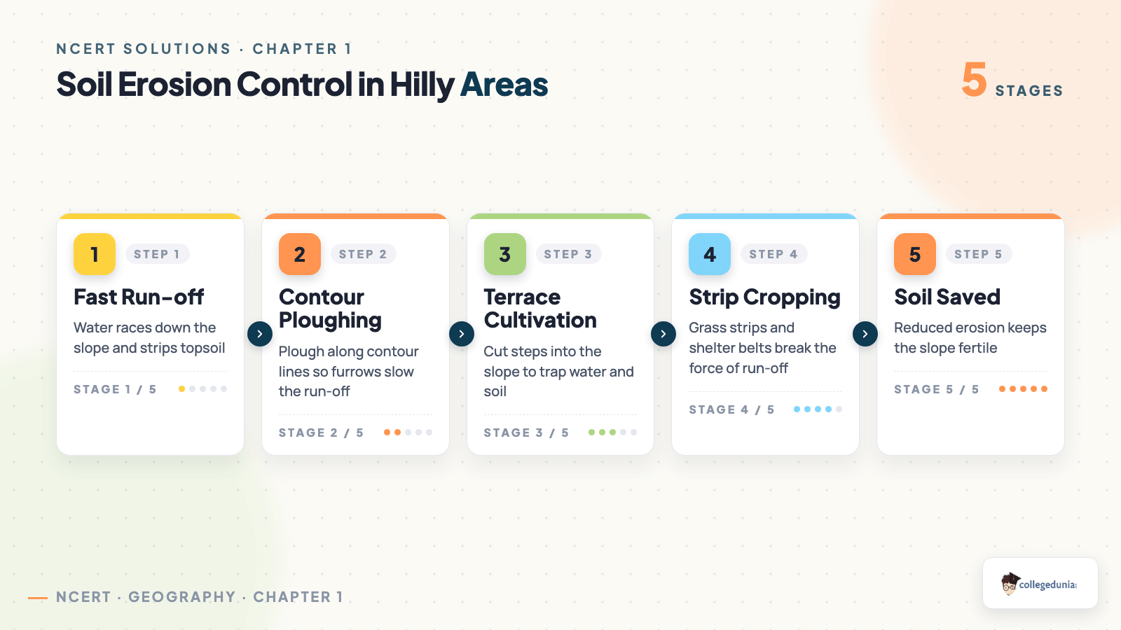
- Steps to control soil erosion in hills: contour ploughing, terrace cultivation and strip cropping with shelter belts.
Memorise the trio contour ploughing, terracing and strip cropping for hills, and keep black soil to cotton ready.
Soil Types of India Explained for Class 10 Geography
The soil types of India are the most asked topic here. The quickest way to remember a soil is to tie it to its parent landform, then its region and crop follow on their own.
| Soil type | Where it forms and what it grows |
|---|---|
| Alluvial soil | Northern Plains and the east-coast deltas (Mahanadi, Godavari, Krishna, Kaveri); very fertile, grows paddy, wheat and sugarcane. |
| Black soil (regur) | Deccan trap lava region, mainly Maharashtra and Madhya Pradesh; holds moisture well and grows cotton. |
| Red and yellow soil | Low-rainfall areas of the Deccan plateau like Jharkhand and Odisha; reddish from iron in crystalline rocks. |
| Laterite soil | High-rainfall hill areas with intense leaching, like the Western Ghats; suits tea, coffee and cashew. |
| Arid soil | Dry western Rajasthan; sandy and saline, low in moisture and humus. |
A handy memory rule: alluvial to plains, black to Deccan lava, laterite to leaching. Naming the parent landform is often worth a mark.
Land Use Pattern and Soil Conservation in This Chapter
The two 120-word questions test the land-use pattern and the development link. India's total geographical area is 3.28 million sq km, but land-use data covers only about 93%, as reporting is incomplete for most north-eastern states.
| Land-use category | What it includes |
|---|---|
| Forests | Recorded forest land; still well below the 33% target of the National Forest Policy of 1952. |
| Land not available for cultivation | Barren and waste land, plus land used for buildings, roads and factories. |
| Other uncultivated land | Permanent pastures, tree crops and culturable waste land. |
| Fallow land | Current fallow and other fallow left unsown for a season or more. |
| Net sown area | The land actually sown with crops; the single largest share of India's land use. |
Forest cover has barely risen since 1960-61 because a growing population drives deforestation for farms, settlements, industry and mining. Note that recorded forest is only an administrative figure, so it can rise on paper without real tree cover increasing.
Common Mistakes Students Make in This Class 10 Geography Chapter
A few slips lose easy marks every year. Fix these before the exam:
- Picking Rajasthan for black soil because it sounds dry. Black soil is volcanic (Deccan trap); Rajasthan has arid soil.
- Writing plains or desert methods for hill erosion. Stabilising sand dunes is an arid-area measure, not a hill one.
- Forgetting the numbers: total area 3.28 million sq km, data for about 93%, forest target 33%.
- Padding a 30-word answer past the limit instead of giving the exact list asked for.
How to Use the NCERT Solutions Class 10 Geography Chapter 1 Page
Use these solutions in three short blocks so revision stays focused. Read the chapter, attempt the questions yourself, then compare and fix the gaps.
- Read and list: read the NCERT chapter and note every soil type, its region and crop.
- Attempt first: answer all 9 questions on your own before opening the solutions.
- Compare and flag: match your answer with the solution and mark the missing fact-lines.
For long-answer practice, write the land-use and resource-consumption answers in full at least once. The ncert solutions class 10 geography chapter 1 resources and development set mirrors the board's 5-mark pattern.
Practice All NCERT Solutions for This Class 10 Geography Chapter with Step-by-Step Solutions
Open the question bank below to attempt all 9 solved questions with collapsible Solution and Expert Solution tabs. Every resources and development question answer is mapped to the NCERT text and reads the way a board examiner expects.
All Solved Questions for this Class 10 Geography Chapter
Practise every MCQ, 30-word and 120-word question with step-by-step solutions and an expert version.
Student Feedback on This Class 10 Geography Chapter
What 14,860 students told us about studying this chapter before the 2026 boards.
- 71% of students rated the soil-type map question as the one they most often answered with the wrong region.
- 58% of students said the land-use 120-word answer was the hardest to keep inside the word limit.
- Most-skipped topic in revision: resource planning in three steps, left for last by about 34% of students.
Source: 2026-27 Class 10 Geography student poll. Sample of 14,860 students from CBSE schools across 15 states.
Class 10 Geography Other Resources for This Chapter
Pair these solutions with the other Class 10 Geography resources for this chapter, all linked below.
| Resource | Best used for |
|---|---|
| Resources and Development Class 10 Notes | Quick concept recap before the exam |
| Resources and Development Class 10 Handwritten Notes | Last-minute scanned revision |
| Resources and Development Class 10 NCERT Book PDF | Reading the original chapter text |
All Chapters NCERT Solutions for Class 10 Geography (Contemp India II)
Browse the full set of ncert solutions for class 10 geography chapter by chapter.
| Chapter | NCERT Solutions |
|---|---|
| Chapter 1 | Resources and Development Class 10 NCERT Solutions |
| Chapter 2 | Forest and Wildlife Resources Class 10 NCERT Solutions |
| Chapter 3 | Water Resources Class 10 NCERT Solutions |
| Chapter 4 | Agriculture Class 10 NCERT Solutions |
| Chapter 5 | Minerals and Energy Resources Class 10 NCERT Solutions |
| Chapter 6 | Manufacturing Industries Class 10 NCERT Solutions |
| Chapter 7 | Lifelines of National Economy Class 10 NCERT Solutions |
Resources and Development Class 10 Geography NCERT Solutions FAQs
Ques. Where can I download the NCERT Solutions Class 10 Geography Chapter 1 Resources and Development PDF?
Ans. You can download the resources and development class 10 ncert solutions PDF directly from this page. Both the Normal and HD versions are free, and a Hindi-medium read is available too.
Ques. How many questions are solved in class 10 geography chapter 1 question answer?
Ans. All 9 NCERT questions are solved: 3 MCQs, 3 short 30-word answers, 2 long 120-word answers and 1 puzzle, each with a step-by-step solution and an expert version.
Ques. Is this NCERT Solutions page aligned with the 2026-27 syllabus?
Ans. Yes. This page reflects the current 2026-27 syllabus for Class 10 Geography, and every answer is checked against the latest NCERT edition of Contemporary India II.
Ques. Why is over irrigation the main cause of land degradation in Punjab?
Ans. In Punjab, Haryana and western Uttar Pradesh, too much canal and tube-well water raises the water table and causes water-logging. As the water evaporates it leaves salt behind, raising the soil's salinity and alkalinity and destroying its fertility.
Ques. Which three states have black soil and what crop grows in it?
Ans. Maharashtra, Madhya Pradesh and Chhattisgarh have black soil, which forms from Deccan-trap lava. The main crop is cotton, which is why it is also called black cotton soil or regur.
Ques. What steps control soil erosion in hilly areas in this chapter?
Ans. In hilly areas soil erosion is controlled by contour ploughing along the contour lines, terrace cultivation that cuts steps into the slope, and strip cropping with shelter belts. All three slow the water flowing down the slope.
Ques. Why has the land under forest not increased much since 1960-61?
Ans. A growing population and economy drive deforestation for farming, settlement, industry, roads and mining, so new plantation barely offsets the losses. Recorded forest is also only an administrative figure, so it can rise on paper without real tree cover increasing.



Comments