




The NCERT class 10 geography notes chapter 1 Resources and Development bring together every definition, classification table, and soil type that the CBSE board paper actually tests in 2026-27.
Chapter1ResourcesandDevelopmentNotes.pdf?page=1&dpi=150)
Chapter1ResourcesandDevelopmentNotes.pdf?page=2&dpi=150)
Chapter1ResourcesandDevelopmentNotes.pdf?page=3&dpi=150)
Chapter1ResourcesandDevelopmentNotes.pdf?page=4&dpi=150)
Chapter1ResourcesandDevelopmentNotes.pdf?page=5&dpi=150)
Chapter1ResourcesandDevelopmentNotes.pdf?page=6&dpi=150)
Chapter1ResourcesandDevelopmentNotes.pdf?page=7&dpi=150)
Chapter1ResourcesandDevelopmentNotes.pdf?page=8&dpi=150)
Chapter1ResourcesandDevelopmentNotes.pdf?page=9&dpi=150)
Chapter1ResourcesandDevelopmentNotes.pdf?page=10&dpi=150)
Chapter1ResourcesandDevelopmentNotes.pdf?page=11&dpi=150)
Chapter1ResourcesandDevelopmentNotes.pdf?page=12&dpi=150)
Chapter1ResourcesandDevelopmentNotes.pdf?page=13&dpi=150)
Chapter1ResourcesandDevelopmentNotes.pdf?page=14&dpi=150)
Chapter1ResourcesandDevelopmentNotes.pdf?page=15&dpi=150)
Chapter1ResourcesandDevelopmentNotes.pdf?page=16&dpi=150)
Chapter1ResourcesandDevelopmentNotes.pdf?page=17&dpi=150)
Chapter1ResourcesandDevelopmentNotes.pdf?page=18&dpi=150)
Chapter1ResourcesandDevelopmentNotes.pdf?page=19&dpi=150)
Chapter1ResourcesandDevelopmentNotes.pdf?page=20&dpi=150)
Chapter1ResourcesandDevelopmentNotes.pdf?page=21&dpi=150)
These notes cover the four bases of resource classification, India's land use pattern, and the six soil types, all according to the latest 2026-27 NCERT Contemporary India II textbook.
- This chapter usually carries 5 to 6 marks across one short answer and one map-based question.
- Most-tested areas: the four bases of resource classification and the six soil types of India.
- Map work on soil distribution and land use appears almost every year.
Each set of class 10 geography notes chapter 1 Resources and Development in this Collegedunia compilation is curated by subject experts, mapped to the 2026-27 NCERT, and refined against the last five years of CBSE board papers.
Student Feedback: What 12,840 students told us about the Resources and Development chapter
71% of Class 10 students surveyed rated the six soil types as the hardest part to memorise. Most students said the classification tables became easy once they were colour-coded.
Source: 2026-27 Class 10 Geography student poll. Sample of 12,840 students from CBSE schools across 14 states.
Resources and Development Meaning and the Four Bases of Classification
A resource is anything in our environment that can satisfy our needs and is technologically accessible, economically feasible, and culturally acceptable. Resources are a function of human activity, not just nature: human beings turn material into resources. The chapter groups every resource under four bases.
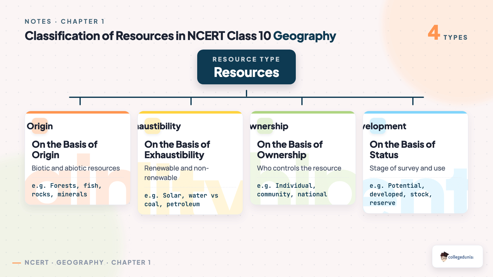
| Basis | Types | Quick Example |
|---|---|---|
| Origin | Biotic and Abiotic | Animals (biotic), rocks (abiotic) |
| Exhaustibility | Renewable and Non-renewable | Solar energy (renewable), coal (non-renewable) |
| Ownership | Individual, Community, National, International | A farm (individual), the ocean beyond 200 km (international) |
| Status of Development | Potential, Developed, Stock, Reserve | Wind in Rajasthan (potential), river water as energy (reserve) |
Origin, exhaustibility, ownership, and status of development are the four labels the board asks you to expand. A one-line example for each type is enough for a short answer.
Renewable and Non-renewable Resources Every Class 10 Student Must Know
Under exhaustibility, resources split into renewable and non-renewable, which decides how carefully we must use each one:
- Renewable resources can be renewed by physical, chemical, or mechanical processes: solar energy, wind, water, forests. They split into flow (solar, wind) and biological (plants, animals).
- Non-renewable resources take millions of years to form: coal, petroleum, minerals. Metals can be recycled; fossil fuels cannot.
Important: for two differences between renewable and non-renewable, speed of renewal and recyclability are the safest points.
Watch the Full Resources and Development Chapter Explained
Source: Magnet Brains on YouTube
Development of Resources and Why Resource Planning Matters
Using resources without a plan creates problems. The chapter lists three caused by careless use, then explains why resource planning is the way out:
- Resources got depleted to satisfy the greed of a few people.
- Wealth got concentrated in a few hands, which divided society into the rich and the poor.
- Indiscriminate use led to global ecological crises like global warming, ozone layer depletion, and pollution.
The chapter pushes for sustainable development, which means development that meets the needs of the present without compromising the ability of future generations to meet their own needs. The 1992 Rio de Janeiro Earth Summit and Agenda 21 are the two facts the board likes to test here.
Resource Planning in India and the Gandhian View
India has enormous diversity in resource availability: some states are rich in minerals but poor in water. Resource planning is therefore a three-step process:
- Identification and inventory of resources across the country's regions through surveying, mapping, and measurement.
- Building a planning structure with the right technology, skill, and institutional setup to use the resources.
- Matching the resource development plans with overall national development plans.
Resources alone cannot bring development; technology and quality human resources are needed too. Colonial history shows many resource-rich regions, including India, stayed poor while colonisers grew rich. Mahatma Gandhi said, "There is enough for everybody's need and not for anybody's greed."
Land Resources and the Land Use Pattern of India
Land is a natural resource of utmost importance: we live, grow food, and build on it. The chapter divides India's relief into mountains, plains, and plateaus, then explains how land is used.
| Relief Type | Share of Land | Main Use |
|---|---|---|
| Plains | About 43% | Agriculture and industry |
| Mountains | About 30% | Rivers, tourism, ecology |
| Plateaus | About 27% | Minerals, fossil fuels, forests |
The net sown area varies a lot: over 80% in Punjab and Haryana but under 10% in Arunachal Pradesh. India's forest area is far below the 33% recommended by the National Forest Policy, a favourite one-mark fact.
Land Degradation and Conservation of Land Resources
Deforestation, overgrazing, mining, and over-irrigation all degrade land and reduce soil quality. The board frames the question around both the causes and the cures:
- Deforestation and overgrazing degrade land in states like Madhya Pradesh, Rajasthan, Maharashtra, and Gujarat.
- Mining leaves deep scars and debris in Jharkhand, Chhattisgarh, Madhya Pradesh, and Odisha.
- Over-irrigation causes waterlogging and rising salinity in Punjab and Haryana.
- Mineral processing, like grinding limestone for cement, releases dust that settles on land and slows plant growth.
Conservation measures include afforestation, grazing management, shelter belts, stabilising sand dunes, managing wasteland, control of mining, and proper discharge of industrial waste. These are the recommended answer to any "how to conserve land" question.
Soil as a Resource and the Factors That Form It
Soil is the most important renewable natural resource, supporting plant growth and the whole food chain. It takes millions of years to form, about one centimetre over hundreds of years. Relief, parent rock, climate, vegetation, and time all shape soil:
- Relief, parent rock, and climate decide the colour, texture, and minerals of a soil.
- Running water, wind, and temperature changes break rocks into the fine particles that become soil.
- Soil is classified by colour, thickness, texture, age, and chemical and physical properties.
Tip: the board often asks why soil is called a living resource. The answer is that soil contains humus and micro-organisms, and it supports plant and animal life.
Six Types of Soils Found in India for Class 10 Boards
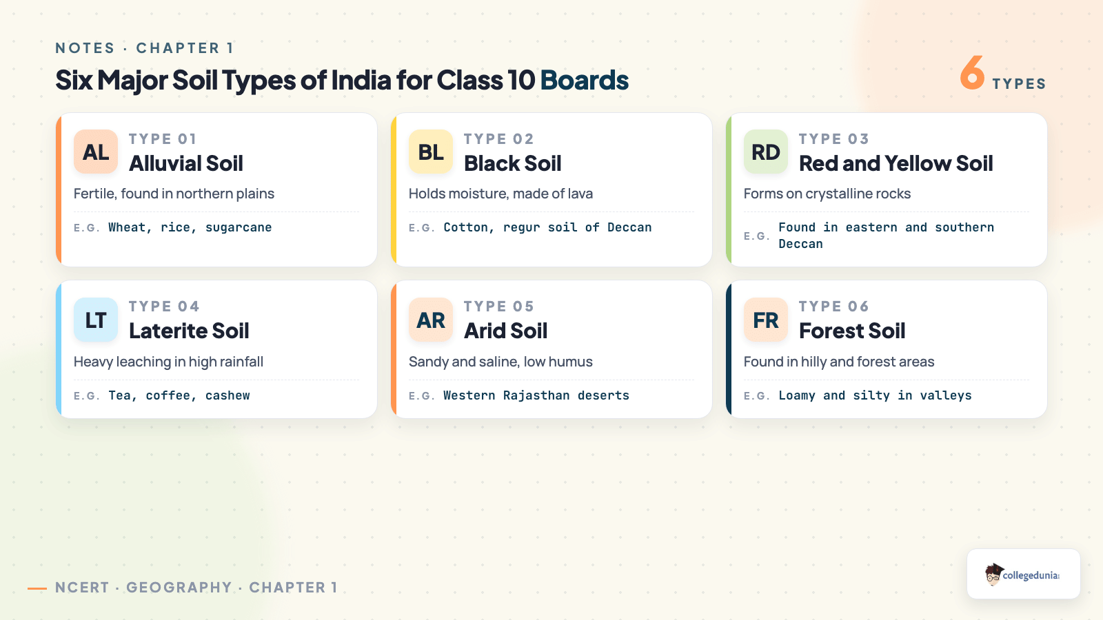
India has six major soil types, each in a different part of the country. This is the single most tested part of the chapter. The comparison table below lays them all out:
| Soil Type | Where Found | Key Features and Crops |
|---|---|---|
| Alluvial | Northern plains, river valleys, eastern coastal plains | Most fertile and widespread; rich in potash and lime; grows wheat, rice, sugarcane. Old soil is bangar, new soil is khadar. |
| Black (Regur) | Deccan plateau: Maharashtra, Madhya Pradesh, Gujarat | Made from lava; holds moisture well; ideal for cotton; develops cracks in summer. |
| Red and Yellow | Eastern and southern Deccan, Odisha, Chhattisgarh | Red due to iron in crystalline rocks; yellow when hydrated; low in humus. |
| Laterite | Karnataka, Kerala, Tamil Nadu, Madhya Pradesh, hilly Assam and Odisha | Forms in high heat and heavy rain; good for tea, coffee, cashew when manured. |
| Arid | Western Rajasthan | Sandy and saline; low humus and moisture; lacks water but high salt content. |
| Forest | Hilly and mountainous areas with rainforests | Loamy and silty in valleys; coarse-grained on upper slopes. |
Alluvial soil is the most fertile and covers the largest area in India. Black soil is best for cotton, which is why it is also called black cotton soil. Memorise one location and one feature per soil type, and the map question is secure.
Soil Erosion and Soil Conservation Methods with Examples
Soil erosion is the removal of topsoil by wind and water, stripping the fertile top layer and ruining farmland. The main types and the conservation methods that stop them:
- Gully erosion: running water cuts deep channels, creating badland or ravines, as in the Chambal basin.
- Sheet erosion: water washes away the topsoil in a thin, even layer over a wide area.
- Wind erosion: strong wind blows away loose soil from flat or sloping land.
The chapter lists clear conservation methods. Contour ploughing means ploughing along the contour lines of a slope. Terrace farming cuts steps into hillsides, as in the western and central Himalayas. Strip cropping leaves strips of grass between crops to break the wind. Shelter belts of trees have helped stabilise sand dunes and check desert spread in western India.
Important Questions and Previous Year Trends for the Resources and Development Chapter
The board tests this chapter through definitions, classification, and map work. The most repeated question types from past CBSE papers:
- One-mark: define resource, name the most fertile soil, state the recommended forest cover.
- Three-mark: classify resources on the basis of ownership; explain three causes of land degradation.
- Five-mark: describe any three soil types with their location and crops; explain soil conservation methods.
- Map work: mark areas of black soil, laterite soil, and major land use regions on an outline map of India.
Practise the six soil types as a table and the four bases of classification as a flow chart. That covers about 80% of what the chapter asks in the 2026-27 session.
How These Notes Pair with NCERT Solutions and the Book PDF
Pair these notes with the other resources for the same chapter:
| Resource | Best For | Open |
|---|---|---|
| NCERT Solutions | Model answers to every back-exercise question | NCERT Solutions for Resources and Development |
| Handwritten Notes | Quick one-shot revision before the exam | Handwritten Notes for Resources and Development |
| NCERT Book PDF | Reading the original chapter text | NCERT Book PDF for Resources and Development |
All Chapters Notes for Class 10 Geography Contemporary India II
Once this chapter is done, move to the next chapters of the book. Each link below opens the Notes page for that chapter in the same subject.
| Chapter | Topic | Notes Link |
|---|---|---|
| Chapter 2 | Forest and Wildlife Resources | Forest and Wildlife Resources Class 10 Notes |
| Chapter 3 | Water Resources | Water Resources Class 10 Notes |
| Chapter 4 | Agriculture | Agriculture Class 10 Notes |
| Chapter 5 | Minerals and Energy Resources | Minerals and Energy Resources Class 10 Notes |
| Chapter 6 | Manufacturing Industries | Manufacturing Industries Class 10 Notes |
| Chapter 7 | Lifelines of National Economy | Lifelines of National Economy Class 10 Notes |
Ques. What is the meaning of a resource in class 10 geography notes chapter 1 Resources and Development?
Ans. A resource is anything in our environment that can be used to satisfy our needs, as long as it is technologically accessible, economically feasible, and culturally acceptable. Human beings turn material into resources.
Ques. What are the four bases of classification of resources?
Ans. Resources are classified on the basis of origin (biotic and abiotic), exhaustibility (renewable and non-renewable), ownership (individual, community, national, international), and status of development (potential, developed, stock, reserve).
Ques. Which is the most fertile and most widespread soil in India?
Ans. Alluvial soil is the most fertile and covers the largest area in India. It is found across the northern plains and river valleys and grows wheat, rice, and sugarcane. Old alluvial is bangar and new alluvial is khadar.
Ques. What are the six types of soils covered in the geography notes for class 10 chapter 1?
Ans. The six soil types are alluvial, black, red and yellow, laterite, arid, and forest soil. Black soil is best for cotton, while laterite soil suits tea, coffee, and cashew.
Ques. What is soil erosion and what are its main types?
Ans. Soil erosion is the removal of topsoil by wind and water faster than it can form. Its main types are gully erosion, sheet erosion, and wind erosion. The Chambal basin badland is a known example of gully erosion.
Ques. What methods are used for soil conservation?
Ans. Soil conservation methods include contour ploughing, terrace farming, strip cropping, and planting shelter belts of trees. These methods slow water and wind so the topsoil stays in place.
Ques. Why is resource planning important in India?
Ans. Resource planning is important because resources are not spread evenly across India. Planning helps identify resources, build the technology to use them, and match resource use with national development so resources are not wasted.
Ques. How much weightage do the class 10 geography notes chapter 1 Resources and Development carry in the board exam?
Ans. The chapter usually carries about 5 to 6 marks in the CBSE board paper for the 2026-27 session, split across a short answer and a map-based question on soil distribution or land use.



Comments